Danube Cycle Path Stage 3 South Bank: Linz - Ardagger


- culturally interesting
- Multi-day tour
Interactive elevation profile
Create PDF
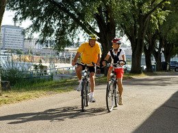
Tour-Details
Paths covering:
A cultural break in the shadows of the Linz City Tower
Recommended season:
- March
- April
- May
- June
- July
- August
- September
- October
- Multi-stage route
- Scenic
- Refreshment stops available
- Cultural/historical value
- Botanical highlights
There is so much to see in Linz, from the historical center with main square and Landstrasse, the Castle Museum, the Botanical Garden, the Musical Theatre at the Volksgarten, Lentos Museum and the Ars Electronica Center, Postlingberg and all its sights… If leaving is difficult for you, comfort yourself with the thought that this stage is going to have a “cultural (inte)rest” for you in Enns.
Before that, your route follows the northern branch of the Danube Bike Path to Steyregg. After crossing the river to the south bank via the power station Abwinden-Asten, you have two promising options for a side trip. One leads you to St. Florian, a beautiful monastery of the Augustinian Canons, with its world famous Bruckner organ and Altdorfer altar. The other option (near Enghangen) takes you to Enns.
Enns is steeped in history and one of Austria’s oldest cities. Guided tours are a perfect way of exploring every part of it. The remains of the old city fortification, the 60 m high 16th c city tower built during the Reformation and the Baroque and Renaissance houses on the main square are all equally enchanting. And maybe you can even pay a short visit to the Roman Museum and Ennsegg Castle.
Just beyond Enns you reach the Lower Austrian Mostviertel, a district named after “most”, the pear cider produced there. Lots of local inns serve this special cider – a perfect opportunity for a break. On reaching Wallsee, you are invited to visit another Roman Museum, which illustrates just how far back the region’s history goes. Wallsee Castle – once inhabited by Habsburg Archduke Franz Salvator – also played a central role in this eventful history. The Mostviertel is at its most scenic as you pedal your way to Ardagger, today’s destination.
Directions:Linz - Steyregg - Enns - St. Pantaleon - Wallsee - Ardagger
Route description
You start your tour in the Flussgasse (street) in Linz, near the new city hall. From there you can easily find the Danube dam, which runs directly along the river and affords a nice view of the Danube bend in Linz and also of the Pöstlingberg (hill).
You further continue on the Donauradweg past Steyregg, a name which should be familiar to all castle enthusiasts. Go over the weir of the Danube power plant Abwinden-Asten to cross the Danube River and continue on the south bank of the river. The Danube Bike Path takes you first through sparse forests where you also pass two small bodies of water. Shortly thereafter you bear to the left and continue downstream. You pass through the small town of Enghagen and pedal onward along the Danube banks. All culture lovers should venture a short side trip to Enns - the oldest city in Austria - as Lauriacum was situated here. Lauriacum was a legion base and an important Roman city along the Danube limes in Austria. A side trip to St. Florian is also worthwhile for the Baroque abbey and the Anton Bruckner organ. The Enns River is also the border between Upper Austria and Lower Austria and its presence means you have to use the bicycle ferry to cross this tributary of the Danube. You are then in the Mostviertel region, where the tour continues through a forest along the Danube. Wild garland is blooming here and its fragrance very much in the air.
Past Albing you once again move away from the Danube and bike through St. Pantaleon. From this point you continue towards our goal on the well-signposted Danube Bike Path in the Mostviertel. The Most Road traverses the largest contiguous area of cultivation for cider pear trees in Europe, the Mostviertel to the south of the Danube in Lower Austria. The road leads past many Mostviertel restaurants, Most Road vendors and farms that market products directly. After a while you finally reach Wallsee, where you once again can marvel at a castle. Afterwards you continue quite a while along the Danube and through the cultivation area for cider pear trees in the direction of Ardagger. In Ardagger it is worthwhile to visit to 950 year old abbey, which was converted into a castle in 1813.
further information:
- Multi-day tour
- Board possible
")

")
")
")


")


")


")
")
")
")
Getting there
From Munich follow the A8 to Salzburg. In Austria follow the A1 to LinzPublic Transit
Take the train from Munich to Linz, and continue in Linz with the tram to the stop Rudolfstraße.Parking
Urfahraner Jahrmarktgelände (Free parking at Urfahr fairgrounds)
- Spring
- Summer
- Autumn
Please get in touch for more information.
Lindengasse 9
4040 Linz
Phone +43 732 7277 - 800
Fax machine +43 732 7277 - 804
E-Mail info@donauregion.at
Web www.donauregion.at
Web www.donauregion.at/
https://www.donauregion.at/
Vis-à-vis users
1. The tours presented for hiking, walking, biking and road biking, mountain biking, motorbiking, horseback riding, climbing, cross-country skiing, and going on skiing and snowshoe tours etc. are to be considered non-paid tour recommendations and only serve as non-binding information. We have no intention of concluding a contract with the users of this website. The utilisation of the data does not lead to the establishment of a contract with us.
The data may only be used for private use; any commercial use is prohibited. In particular, it is not permissible to offer the data on commercially run websites, file-sharing platforms etc. or to use it to develop commercial products. Downloading data does not imply that users are granted rights to the data concerned.
The tour recommendations posted were created with utmost care; nevertheless, we assume no liability for the correctness and completeness of the information.
We point out that neither the tour recommendations included on this website nor the associated data and information were posted by us, but rather by third parties (Art. 16 Austrian E-Commerce Act). We have no influence on whether the details provided (e.g. distance, level of difficulty, change in altitude, description etc.) are authentic, correct and complete. We do not review these third-party contents. For this reason, we assume no liability for the authenticity, correctness and completeness of the information.
Construction-related measures or other influences (e.g. landslides and similar occurrences) can lead to temporary or permanent changes in a route (e.g. loss of a bridge and similar occurrences). Such occurrences can lead to part of the route or the entire route becoming impassable.
The use of the data as well as undertaking (riding, walking, taking etc.) the recommended tours or using the network of paths occurs at users’ own risk and on their authority. In particular, users themselves are responsible for the choice of route, outdoor orientation, adherence to traffic rules, supplies and equipment for tours listed in Point 1 (e.g. bicycle etc.), wearing a helmet, estimating their own fitness, recognising dangers and maintaining an appropriate velocity. We exclude ourselves from any liability whatsoever for damages, in particular accidents, that occur whilst taking part in the recommended tours.
2.Some of the tours lead over roads with normal traffic conditions. Please observe that there is an increased risk which can be avoided by means of appropriate attention and proper estimation and implementation of one’s own abilities. For this reason, please travel a route that is unfamiliar to you slowly and with special care. Pay constant attention to potential dangers and always observe traffic. Do not leave the routes featured in descriptions.
The potential use of private roads, in particular forestry roads and agricultural transport roads, can be subject to legal restrictions, which must be observed and adhered to.
The normal traffic rules apply. Each user (e.g. biker, motorbiker) is responsible for adhering to these rules and maintaining his/her bike/vehicle and its equipment (lights, brakes etc.) in good working order. Each user is also responsible for ensuring that he/she rides at a velocity that is appropriate for the conditions and his/her skill level and for maintaining sufficient distance to the rider in front. We explicitly recommend adjusting velocity to correspond to the respective field of vision, wearing a helmet, using reflective clothing (or similar) and employing bicycle lights in line with regulations.
3.Each tour requires good physical fitness as well as detailed planning. We explicitly recommend only taking the tours in the case of optimal healthiness.
We recommend that you conclude an accident and liability insurance policy. Use an onboard computer that displays the respective kilometres travelled per day and is calibrated for the front wheel.
4.Special for mountain bikers – Fair-play rules:
Mountain biking is one of the most wonderful outdoor leisure-time activities. Whilst biking or on a mountain biking tour, mountains and lakes, meadows and cabins are re-discovered in new ways. A couple of rules for fair play in the forest help to avoid conflicts whilst mountain biking.
a.Pedestrians have the right of way: We are accommodating and friendly to pedestrians and hikers. Upon encountering these fellow travellers, we alert them by using the bicycle bell and slowly overtake them. We avoid paths with heavy pedestrian traffic altogether. Take nature into account: We do not leave refuse behind.
b.The braking distance should be half of the total distance visible: We ride at a controlled pace, are ready to brake and maintain a braking distance half as long as the total distance visible, especially in curves, because we always have to count on obstacles on the path. Damage to the path, stones, branches, wood piles, grazing livestock, cattle grids, barriers, tractor-type forestry machines and authorised vehicles pose dangers that we need to be ready for.
c.Don’t drink and drive!: Do not drink alcohol when mountain biking. Take care at stop-off points (dealing with bike racks, dirty shoes or clothing).
It is obligatory to provide first aid!
d.Marked routes, closed paths and blockades: Keep to the marked routes, observe the blockades and accept that these roads are primarily for agricultural and forestry use!
Blockades can often not be avoided and are in your own interest. Biking beyond the intended path and outside of opening times is punishable and turns us into illegal bikers.
e.We are guests in the forest and behave accordingly, including vis-à-vis forestry and hunting staff. Whilst mountain biking, mobile telephones and music players are forbidden! Biking requires your full attention.
f.Avoid unnecessary noise. Out of consideration to the animals living in the wild, we only bike during full daylight. As a principle, we always wear our helmet (even when riding uphill)! Don’t forget emergency supplies: We always have a repair set and bandages along.
g.Don’t overestimate your skills: We should not overdo it when it comes to biking technique and physical fitness. Take the level of difficulty posed by the route into consideration and make a precise estimate of your experience and skills as a biker (braking, bell, lights)!
h.Close gates: We approach grazing livestock at a walking pace and close every gate behind us. We should avoid causing escape and panic reactions in the animals. Nothing stands in the way of the fun and athletic challenge in the mountains and forests!
i.Traffic rules: The general traffic rules (StVO) apply for all the mountain biking routes and we adhere to them. Our bike therefore needs to be in perfect technical condition and equipped in line with the traffic rules, including brakes, a bell and lights. We inspect and service our mountain bikes regularly anyway.
5.We assume no liability for the contents of external websites; in particular, we assume no liability for their statements and contents. Moreover, we have no influence on the design or contents of the websites to which hyperlinks on guide.oberoesterreich.at lead or from which hyperlinks lead to guide.oberoesterreich.at. There is no on-going review of websites to which hyperlinks on guide.oberoesterreich.at lead or from which hyperlinks lead to guide.oberoesterreich.at. We do not appropriate the contents of websites to which hyperlinks on guide.oberoesterreich.at lead or from which hyperlinks lead to guide.oberoesterreich.at.
Vis-à-vis bloggers
PLEASE OBSERVE:
1. Each of your tour recommendations for hiking, walking, biking and road biking, mountain biking, motorbiking, horseback riding, climbing, cross-country skiing, and going on skiing and snowshoe tours etc., along with other details and information, is free of charge. In particular regarding the correctness of the information, we assume no liability, nor do we assume any liability whatsoever for the consequences of the use of your tour recommendation by a third party (in particular by a user of this website). We do not review the tour recommendations you post, including other details and information, at any time.
We have no intention of concluding a contract with persons who post tour recommendations and/or other details and information on this website. Posting data (information) does not imply that a contract has been concluded.
By recommending a tour, we assume special responsibility vis-à-vis other athletes. Please take this responsibility seriously and describe your tour recommendation with utmost care and to the best of your knowledge and belief.
2.Your tour recommendations must therefore clearly and unambiguously include at least the following criteria and provide a sufficiently detailed description:
• Starting point
• Detailed route description
• Distance/Overall distance
• Level of difficulty
• Dangerous spots
• Average duration of trip
• Change in altitude
• Finishing point.
If possible, please provide the change in altitude.
3.When you post a tour recommendation, you give us the order to save your tour recommendation and/or the details you provide on our website and to make it/them accessible to third parties, in particular to users of this website, in the long term. We reserve the right to block or delete tour recommendations and/or other details and/or information that you post, either partially or entirely, at any time without providing a justification. Should this occur, it grants you no rights whatsoever.
Thank you for your efforts!
4. We are not responsible for the contents of external websites; in particular, we do not assume any liability for their statements or contents. Furthermore, we do not influence the design or contents of websites that can be accessed from guide.oberoesterreich.at via hyperlinks or that use hyperlinks to refer to guide.oberoesterreich.at. The websites that can be accessed from guide.oberoesterreich.at via hyperlinks or that use hyperlinks to refer to guide.oberoesterreich.at are not regularly monitored. Furthermore, we do not assume any claims to the websites that can be accessed from guide.oberoesterreich.at via hyperlinks or that use hyperlinks to refer to guide.oberoesterreich.at.
Interactive elevation profile
Create PDF
Tour-Details
Paths covering: