Donausteig Stage 3_N06 Ottensheim - Linz: „Summit Assualt-From the Eferdinger Basin to the Linzer Basin“


- culturally interesting
- Multi-day tour
Interactive elevation profile
Create PDF
Tour-Details
Paths covering:
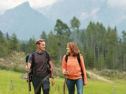
The Donausteig-simply fabulous! Summit storm onto the Donaublick - one of the seven Danube climbing summits! On this panoramic stage, we hike from Ottensheim in the fertile Eferding basin over the summits of the Donaublicks and the Pöstlingberg to the Linzer basin to Linz. We discover Ottensheim as an ancient trading hub, the myth of the Lochsteines (stones), the landmark of Linz, the innovative Maximillian fortress, the steepest adhesion railway in the world of...
Recommended season:
- March
- April
- May
- June
- July
- August
- September
- October
- Multi-stage route
- Scenic
- Refreshment stops available
- Cultural/historical value
- Insider tip
- Summit route
Seal of approval:
- Quality route according to "Österreichisches Wandergütesiegel"
Starting point for this leg of the Donausteig is Ottensheim. The historic Danube market is located on the eastern edge of the fertile Eferding basin and has a historically important Danube crossing. The beautiful marketplace tells of a long tradition as a trading hub. From the pier of the Rollfähre (ferry) we walk along the Danube on the Treppelweg (path). While the Danube can be wonderful observe and ponder about the former activities on the Danube crossing. At the Danube bend, where the current flows further into the Kerbtal (valley) of the Linzer gateway, we leave the river and begin our summit assault. After a short section of forest we walk up the Dürnberg (mountain) past rural surroundings: lush meadows, farm fields, beautiful fruit fields, solitary farms,... We quickly gain height on dirt farm roads. Our field of view widens as more and more of the whole Eferding basin becomes apparent - simply beautiful! The Donausteig-resting point "Dürnberg" gives us a nice opportunity for a comfortable break. After a small wooded area, we are at the height of the Linzer gateway and can see the narrow gorge of the Danube River. After a short forest descent, we then walk back on farm and dirt roads through rural cultural landscape uphill towards Koglerau. The unique panoramic terrace of the Kögler Court provides the setting to ponder. From there, a footpath through the atmospheric forest of the Koglerau leads us to the summit cross of the Donaublick, the first experience highlight of this Donausteig-stage. Congratulations - here we are on one of the seven leading peaks of the Donausteig! One last time the view of the fertile Eferding basin opens up to us. Now, the path to the Linzer basin begins. After the summit the view into the new landscape opens us for the first time. Over meadows and fields, passing scattered settlements, on a long up and down, we reach the symbol of Linz is the Pöstlingberg with its pilgrimage church - the second adventure highlight of this Donausteig-stage which offers a unique view from the Linzer basin all the way to the Alps - simply fabulous! Here long stay is worth it, because there is so much to discover. Then, a way of the cross leads us through meadows and woodland down to the Petrinum at the foot of the Pöstlingberges (mountain). From there the walk is through the city and over the Danube bridge to the magnificent main square of Linz. A diversified Danube climbing experience between nature and culture - simply fabulous!
Discover the following features with the Donausteig-diary:
-Ottenheim-a crossway and trading site
-Donausteig-starting point "Ottensheim"
-Danube ferry Ottensheim Wilhering
-Danube power plant Ottensheim Wilhering
-Abbey Wilhering uniqueness through fire
-Donausteig-resting point "Dürnberg"
-Lochsteine-Jewels for the hereafter?
-Kürnberg-the Emperors forest
- ...
Download: Donausteig-diary "Stage 3_N06 Ottensheim Linz" - yet to follow!
Directions:From the Donausteig-starting point in Ottensheim we follow the Treppelweg (path) along the Danube downstream until it under the Bundesstraße B127 reaches an asphalt road. We follow the road right to the Inn "Dürnberg". Immediately turn left and continue under the main road and in a loop over the bridge towards the road tunnel. On the other side of the bridge turn right where the paths leads through a beautiful forest along the Schröckingerbachs (stream) uphill. After about 80 m turn left. Here we leave the trench and walk to the asphalt road (next to square yard) over dirt roads in a slight curve to the right. We follow this turn right uphill until it end at the next farm. A dirt road in a long right-curve continues uphill to the next crossing with an asphalt road (next to a farm). We cross it and come across a dirt road which continues uphill to the Donausteig-resting point "Dürnberg". Through a forest stretch (Lochstein), past a chapel we wander a short distance along the forest edge (view of the Kürnberg (mountain)). This is followed by a short descent through the forest up to some hidden houses. We cross the river and reach the paved farm road on the opposite side of a dirt road. We continue up to a Y-junction- turn left through a depression. Turn Right uphill. On the road, we go around a small wooded area to the West and then turn at the farm right. Over dirt roads, we finally come to the Köglerhof (court). Straight ahead on a trail uphill we are shortly thereafter at the hidden forest Summit of the Koglerau (boulders, Wooden sign, sitting opportunities). Here we follow the Ridge South (right). After about 80 m, we arrive at a crossroads. Turn right, and a short detour brings us to our Donausteig-summit, the summit of the Donaublick. Turn left, and we walk downhill from the peak forest, and arrive past a settlement a junction with the paved Grossambergstraße (Marienkapelle (Chapel)). Now turn left and continue across the meadows and fields. The next road that turns right, leads us quickly downhill. After a small settlement, a forest road leads us on some bends down to the creek. After the crossing, a forest trail leads uphill on the opposite sided slope. Uphill, at the junction with the settlement road, we turn left. In a long right bend we pass the Inn Freiseder and reach the main square at the Pöstlingberg cemetery. Turn left and after 50 m turn right and walk uphill. Shortly thereafter, the road continues to the Pöstlingberg (mountain). The next intersection is at the track crossing of the Pöstlingbergbahn. Here begins the short detour to the Donausteig-resting point "Pöstlingberg Plattform". We turn back left to the road through the gate of the fortress and go right up to the observation deck. For the descent to Linz, we cross the tracks and wander downhill to the right the narrow walkway. Shortly thereafter, we arrive onto the way of the cross, which quickly brings us over gravel and dirt roads to the Petrinum at the foot of the Pöstlingberg. At the beginning(!) of its powerful main building, the Donausteig takes a sharp right turn onto the Leistenhofstraße (street). At the T‑Kreuzung, turn left and follow the Wischerstrasse (street) up to the next crossing. Turn right along the Doppelbauerwegs (path) back up to the next crossing. We follow the Rosenauerstraße (street) left for a longer time until we reach a park-like intersection (fountains). From here the road takes us right straight through Urfahr across the Danube bridge to the Linz's main square.
To facilitate the orientation, the Donausteig was provided with its own system of orientation - you will find the description here .
Tip:The Maximilianische fortress, the Grotto railway, the sanctuary, the view over Linz,... all highlights that make the Ausflugsberg (mountian) unique. And crowning the descent with the Pöstlingbergbahn, the steepest adhesion railway in the world.Equipment:
Sturdy shoesAdditional information:
WGD Tourismus GmbH
Lindengasse 9
4040 Linz, Austria
Tel. +43(0)732/7277-800
Fax. +43(0)732/7277-804
info@donausteig.com
Tourism center Ottensheim
Marktplatz 7
4100 Ottensheim, Austria
Telefon: +43 (0)7234 82255 30
Mobil: +43 (0)699 10437643
Fax: +43 (7234)82255 34
ottensheim@oberoesterreich.at
http://www.oberoesterreich.at/ottensheim
Gemeindeamt Tel.: +43(0)7234/822550
Tourist Information Linz
Hauptplatz 1
4020 Linz
Tel.: +43(0)732-7070-2009
Fax: +43(0)732-7070-542009
tourist.info@linz.at
www.linz-tourismus.info und www.linz.at/tourismus
further information:
- Multi-day tour
- Board possible
")
")
")
")

")
")
")
")


")

Direction information: Departure
Direction information: right
Direction information: right
Direction information: straight ahead
Direction information: left
Direction information: straight ahead
Direction information: left
Direction information: straight ahead
Direction information: right
Direction information: Destination
")
")
")
")
")
")
")

LinzTourismus-Röbl.jpg (© TVL-Röbl)")
")
")

OÖ Landesmussen.jpg (© OÖ Landesmuseen)")
LinzTourismus-Müller.JPG (© TVL-Müller)")
")
")
")
")
Norbert Artner.jpg (© Norbert Artner)")
")
")
")
")
")
")
")
Getting there
The Donausteig-starting point lies to the south exit of Ottenheim's Market square (Navi: A-4100 Ottensheim, Marktplatz).Public Transit
Ottensheim can be reached by bus and train. A transfer back from Linz is possible as well by bus or train. If you take the train be aware that the train statiosn are further away from their respective city centers! Information on time tables online at http://www.ooevv.at .Parking
The market center of Ottensheim is largerly a short period parking zone - as well the zone close to the ferry dock. Free of charge parking zones can be found at the Donauhalle (approx. 5 walking minutes away: Nähe Donaulände) or at the parking lot at the school center (approx. 10 walking minutes away: north of the parish church).
- Spring
- Summer
- Autumn
Please get in touch for more information.
Lindengasse 9
4040 Linz
Phone +43 732 7277 - 800
mobile +43 699 10437643
Fax machine +43 732 7277 - 804
E-Mail info@donauregion.at
Web www.donauregion.at
Web www.linztourismus.at/
https://www.linztourismus.at/
Vis-à-vis users
1. The tours presented for hiking, walking, biking and road biking, mountain biking, motorbiking, horseback riding, climbing, cross-country skiing, and going on skiing and snowshoe tours etc. are to be considered non-paid tour recommendations and only serve as non-binding information. We have no intention of concluding a contract with the users of this website. The utilisation of the data does not lead to the establishment of a contract with us.
The data may only be used for private use; any commercial use is prohibited. In particular, it is not permissible to offer the data on commercially run websites, file-sharing platforms etc. or to use it to develop commercial products. Downloading data does not imply that users are granted rights to the data concerned.
The tour recommendations posted were created with utmost care; nevertheless, we assume no liability for the correctness and completeness of the information.
We point out that neither the tour recommendations included on this website nor the associated data and information were posted by us, but rather by third parties (Art. 16 Austrian E-Commerce Act). We have no influence on whether the details provided (e.g. distance, level of difficulty, change in altitude, description etc.) are authentic, correct and complete. We do not review these third-party contents. For this reason, we assume no liability for the authenticity, correctness and completeness of the information.
Construction-related measures or other influences (e.g. landslides and similar occurrences) can lead to temporary or permanent changes in a route (e.g. loss of a bridge and similar occurrences). Such occurrences can lead to part of the route or the entire route becoming impassable.
The use of the data as well as undertaking (riding, walking, taking etc.) the recommended tours or using the network of paths occurs at users’ own risk and on their authority. In particular, users themselves are responsible for the choice of route, outdoor orientation, adherence to traffic rules, supplies and equipment for tours listed in Point 1 (e.g. bicycle etc.), wearing a helmet, estimating their own fitness, recognising dangers and maintaining an appropriate velocity. We exclude ourselves from any liability whatsoever for damages, in particular accidents, that occur whilst taking part in the recommended tours.
2.Some of the tours lead over roads with normal traffic conditions. Please observe that there is an increased risk which can be avoided by means of appropriate attention and proper estimation and implementation of one’s own abilities. For this reason, please travel a route that is unfamiliar to you slowly and with special care. Pay constant attention to potential dangers and always observe traffic. Do not leave the routes featured in descriptions.
The potential use of private roads, in particular forestry roads and agricultural transport roads, can be subject to legal restrictions, which must be observed and adhered to.
The normal traffic rules apply. Each user (e.g. biker, motorbiker) is responsible for adhering to these rules and maintaining his/her bike/vehicle and its equipment (lights, brakes etc.) in good working order. Each user is also responsible for ensuring that he/she rides at a velocity that is appropriate for the conditions and his/her skill level and for maintaining sufficient distance to the rider in front. We explicitly recommend adjusting velocity to correspond to the respective field of vision, wearing a helmet, using reflective clothing (or similar) and employing bicycle lights in line with regulations.
3.Each tour requires good physical fitness as well as detailed planning. We explicitly recommend only taking the tours in the case of optimal healthiness.
We recommend that you conclude an accident and liability insurance policy. Use an onboard computer that displays the respective kilometres travelled per day and is calibrated for the front wheel.
4.Special for mountain bikers – Fair-play rules:
Mountain biking is one of the most wonderful outdoor leisure-time activities. Whilst biking or on a mountain biking tour, mountains and lakes, meadows and cabins are re-discovered in new ways. A couple of rules for fair play in the forest help to avoid conflicts whilst mountain biking.
a.Pedestrians have the right of way: We are accommodating and friendly to pedestrians and hikers. Upon encountering these fellow travellers, we alert them by using the bicycle bell and slowly overtake them. We avoid paths with heavy pedestrian traffic altogether. Take nature into account: We do not leave refuse behind.
b.The braking distance should be half of the total distance visible: We ride at a controlled pace, are ready to brake and maintain a braking distance half as long as the total distance visible, especially in curves, because we always have to count on obstacles on the path. Damage to the path, stones, branches, wood piles, grazing livestock, cattle grids, barriers, tractor-type forestry machines and authorised vehicles pose dangers that we need to be ready for.
c.Don’t drink and drive!: Do not drink alcohol when mountain biking. Take care at stop-off points (dealing with bike racks, dirty shoes or clothing).
It is obligatory to provide first aid!
d.Marked routes, closed paths and blockades: Keep to the marked routes, observe the blockades and accept that these roads are primarily for agricultural and forestry use!
Blockades can often not be avoided and are in your own interest. Biking beyond the intended path and outside of opening times is punishable and turns us into illegal bikers.
e.We are guests in the forest and behave accordingly, including vis-à-vis forestry and hunting staff. Whilst mountain biking, mobile telephones and music players are forbidden! Biking requires your full attention.
f.Avoid unnecessary noise. Out of consideration to the animals living in the wild, we only bike during full daylight. As a principle, we always wear our helmet (even when riding uphill)! Don’t forget emergency supplies: We always have a repair set and bandages along.
g.Don’t overestimate your skills: We should not overdo it when it comes to biking technique and physical fitness. Take the level of difficulty posed by the route into consideration and make a precise estimate of your experience and skills as a biker (braking, bell, lights)!
h.Close gates: We approach grazing livestock at a walking pace and close every gate behind us. We should avoid causing escape and panic reactions in the animals. Nothing stands in the way of the fun and athletic challenge in the mountains and forests!
i.Traffic rules: The general traffic rules (StVO) apply for all the mountain biking routes and we adhere to them. Our bike therefore needs to be in perfect technical condition and equipped in line with the traffic rules, including brakes, a bell and lights. We inspect and service our mountain bikes regularly anyway.
5.We assume no liability for the contents of external websites; in particular, we assume no liability for their statements and contents. Moreover, we have no influence on the design or contents of the websites to which hyperlinks on guide.oberoesterreich.at lead or from which hyperlinks lead to guide.oberoesterreich.at. There is no on-going review of websites to which hyperlinks on guide.oberoesterreich.at lead or from which hyperlinks lead to guide.oberoesterreich.at. We do not appropriate the contents of websites to which hyperlinks on guide.oberoesterreich.at lead or from which hyperlinks lead to guide.oberoesterreich.at.
Vis-à-vis bloggers
PLEASE OBSERVE:
1. Each of your tour recommendations for hiking, walking, biking and road biking, mountain biking, motorbiking, horseback riding, climbing, cross-country skiing, and going on skiing and snowshoe tours etc., along with other details and information, is free of charge. In particular regarding the correctness of the information, we assume no liability, nor do we assume any liability whatsoever for the consequences of the use of your tour recommendation by a third party (in particular by a user of this website). We do not review the tour recommendations you post, including other details and information, at any time.
We have no intention of concluding a contract with persons who post tour recommendations and/or other details and information on this website. Posting data (information) does not imply that a contract has been concluded.
By recommending a tour, we assume special responsibility vis-à-vis other athletes. Please take this responsibility seriously and describe your tour recommendation with utmost care and to the best of your knowledge and belief.
2.Your tour recommendations must therefore clearly and unambiguously include at least the following criteria and provide a sufficiently detailed description:
• Starting point
• Detailed route description
• Distance/Overall distance
• Level of difficulty
• Dangerous spots
• Average duration of trip
• Change in altitude
• Finishing point.
If possible, please provide the change in altitude.
3.When you post a tour recommendation, you give us the order to save your tour recommendation and/or the details you provide on our website and to make it/them accessible to third parties, in particular to users of this website, in the long term. We reserve the right to block or delete tour recommendations and/or other details and/or information that you post, either partially or entirely, at any time without providing a justification. Should this occur, it grants you no rights whatsoever.
Thank you for your efforts!
4. We are not responsible for the contents of external websites; in particular, we do not assume any liability for their statements or contents. Furthermore, we do not influence the design or contents of websites that can be accessed from guide.oberoesterreich.at via hyperlinks or that use hyperlinks to refer to guide.oberoesterreich.at. The websites that can be accessed from guide.oberoesterreich.at via hyperlinks or that use hyperlinks to refer to guide.oberoesterreich.at are not regularly monitored. Furthermore, we do not assume any claims to the websites that can be accessed from guide.oberoesterreich.at via hyperlinks or that use hyperlinks to refer to guide.oberoesterreich.at.
Interactive elevation profile
Create PDF
Tour-Details
Paths covering: