Donausteig Stage 4_G06 Grein - Sarmingstein: „Through the wild Strudengau“


- Suitable for families
- Suitable for kids (all ages)
- culturally interesting
- Multi-day tour
Interactive elevation profile
Create PDF
Tour-Details
Paths covering:
Description: Due to logging and clearing work, the hiking trail in the Stillensteinklamm in the municipality of St. Nikola an der Donau will be closed from 1 April 2025 to 30 June 2025.
Please observe the local signposting regarding the current situation on site. Thank you for your understanding!
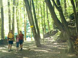
The Donausteig-simply fabulous! This stage takes us through the beautiful Donaukerbtal (valley) of the Strudengau. Once feared by sailors due to its treacherous whirlpool, we today enjoy hiking through this exciting piece of Danube history - from Grein past St. Nikola to Sarmingstein. On this stage we discover Grein as the gateway to the Strudengau, the fabled Stillensteinklamm (Gorge), the most dangerous whirlpools of the entire Danube River run, Castle Säbnich as a bastion in the East...
Recommended season:
- March
- April
- May
- June
- July
- August
- September
- October
- Multi-stage route
- Scenic
- Refreshment stops available
- Family friendly
- Cultural/historical value
- Geological highlights
Grein, the gateway to the Strudengau, is the starting point for this beautiful Donausteig-stage. The historic town was once the last safe docking site efore the dangerous water swirls of the Strudengaus! ... Magnificent facades, elegant Bay Windows, testify to wealth through Danube boat trade. We walk on the Danube promenade up to the Halterkreuz (cross) which today still warns of the once first Strudengau obstacle. From there, the Donausteig leads uphill comfortably through a settlement. A short detour to the Kalvarienberg opens up at a Donausteig-view point wonderful views of Grein and shows us an unusual granite gallery. Hereafter, the urban settlement rapidly changes into rural landscapes and into the typical woodland of the Donaukerbtal (valley). On forest paths in the forest, we hike uphill to the view point of Castle Werfenstein. Then forest trails lead us back down to the Danube to the Gießenbachmühle (mill). Here, one of the most dangerous sections of today starts along the Strudengau!
We leave the Danube though straight away and hike through the wild and romantic Gorge of Stillensteinklamm uphill. The quiet creek soon turns into water Cascades and disappears under the stones for about 300 m - a highlight! There, we leave the gorge on the steep Jägersteig. A short time later we walk high above the Danube enjoyably through attractive mixed forests along the Danube valley. Occasional views of the Danube can still only hint of the former dangers. In a forest clearing the Donausteig-resting "Donaublick" invites us to linger and allows a look back onto the Gobelwarte, one of the seven Danube climbing peaks! Historic trails lead us down to a settlement above Struden. The most powerful whirlpool of the entire Danube were once in Struden! From here, we go through scattered settlements further down the Danube and reach past the old Danube road after a short uphill stretch St. Nikola, the Church of the patron saint of seafarers. Here the dangers of today were once survived. From the Donausteig-resting point just below the Church, we have a wonderful look back onto the former danger!
The last section of the trail is a walking highlight! First the ancient Church way through magnificent forests leads us up the side of the Valley. Then we walk alone through attractive mixed forests along the Danube valley past meadows to the Moststation Kleinleitner (cyder inn). Here, a grand view far beyond the end of the wild Strudengau, - up to the Ötscher! After a magnificent descent, we reach past the historic castle Säbnich, the historic danube settlement of Sarmingstein, the end of the Strudengau. Simply fabulous!
Discover the following features with the Donausteig-diary:
-Grein - the gateway to the Strudengau
-Donausteig-starting point "Grein"
-The castle of Greinburg-the oldest Castle North of the Alps?
-Halterkreuz- votive and warning
-Kalvarienberg-Gallery of granite
-Donausteig-viewing point "Grein"
-castle Werfenstein- toll or chain
-Island Wörth-Rapids and boulders
- ...
Download: Donausteig-diary "Stage 4_G06 Grein Norwich" - yet to follow!
Directions:From the Donausteig-starting point in Grein we go the Donaulände (park) downstream up to the large junction at the end (on the right side is the Halterkreuz stands on a small rock). There left and right again on a footpath continue uphill between houses. The footpath joins the Jubiläumsstraße (road), which we follow. At the railway underpass a short detour is recommended to the right to the Donausteig-viewing point; to the gallery of granite at the Kalvarienberg. After the railway underpass we follow at the next junction the Wiener path through a housing development - first straight on uphill, later in an arc to the left downhill. At the asphalt road out of the Danube valley, we turn right downhill in the direction of the Danube. Shortly thereafter, the "access road Ramersböck" branches off to the left. On this we bear left uphill. At the farmhouse of Ramersböck the Donausteig makes a switchback and now follows a dirt road uphill. On forest roads, we continue and reach after a longer walking time we reach three granite rocks with petroglyphs and a view of castle Werfenstein. Turn Right through the forest down to the Gießenbachmühle (mill) on the river Danube. From the Donausteig-starting point "St. Nikola/Gießenbachmühle" we walk first through forests, then through idyllic hiking paths uphill to the romantic Stillensteinklamm (gorge). Immediately after the stones, characterized as a distinctive roof, we leave the Stillensteinklamm (gorge) to the right on secured steps. At a farm, a short stretch begins an asphalt road, which we leave in a left turn. We walk past the Donausteig-resting point "Donaublick" to a settlement above Struden (Tree sign with a connection to the Castle Wefenstein) along a comfortable forest road. Here we follow the first left on an asphalt road uphill and after 250 m at the next crossing we turn right downhill - St. Nikola is in sight. After a right turn, the Donausteig turn sharply to the left across from an old factory building. By means of a bridge we cross the Danube River Railway, and continue on a footpath through a row of houses down to the Danube. Now under the railway bridge, the Dimbach and the old paved road lead uphill to the Danube-courtyard in St. Nikola. A short detour takes us from here to the Church of St. Nicholas and the underlying Donausteig-resting point "Kirchenplatz“. Hereafter, we circle the Danube courtyard on the north side. At the next intersection turn first left and then right again. We follow the paved road uphill in the direction of the "Sattl Moststation"until the next turn. There the Donausteig turns left and follows a wonderful forest - first quickly uphill, then enjoyably along the side of the Danube valley - Cyder inn Kleinleitner. The following short asphalt stretch is left already after a bend on to the left across a meadow. An atmospheric forest takes us down to Sarmingstein. Arrived at the train tracks, we follow a footpath to the left and walk passed the round tower of the Castle Säbnich to the houses at the Sarmingbach. Right here, we reach the Donausteig-starting point "Sarmingstein"at the inn Strudengauhof.
To facilitate the orientation, the Donausteig was provided with its own system of orientation - you will find the description here .
Tip:The „Oberösterreichische Schifffahrtsmuseum“ (ferry museum) is a must for every Donausteig-hiker! The museum presents the history of the danube boat trips and the usage of the Danube river.Equipment:
Hiking equipment, drinking bottle. Take into consideration that this is a longer and more tiring stage!Additional information:
WGD Tourismus GmbH
Lindengasse 9
4040 Linz, Austria
Tel. +43(0)732/7277-800
Fax. +43(0)732/7277-804
info@donausteig.com
Tourism agency Grein/Donau
Stadtplatz 7
4360 Grein
Tel./Fax: +43(0)7268/7055
info.grein@oberoesterreich.at
www.oberoesterreich.at/grein
Tourism agency St. Nikola
4381 St. Nikola/Donau
Tel.: 0043(0)69913030422
tourismus@struden.at
www.sankt-nikola.at
www.oberoesterreich.at/st.nikola.donau
further information:
- Multi-day tour
- Board possible
")
")


")


Direction information: Departure
")
")
")
")

")
")
")

")


")

")
")
")
")
")
")
")

")
")
")
")
Direction information: Destination
Getting there
The Donausteig-starting point "Grein" is located directly on the Donaulände (park) (Navigation: A-4360 Grein, Donaulände)Public Transit
Grein can be reach by bus and train. The train stop "Grein stadt" lies the closest to the Donuasteig-starting point. A transfer back from Sarmingstein to Grein is possible by bus and train. Timetables online at http://www.ooevv.at .Parking
The parking lot at the Donaulände (park) are only short duration parking zones as are the ones in the city center. Two free of charge parking lots are located approx. 10 walking minutes away (Parking lot at the train station "stadt Grein"; parking lot across from the camping site at the south entrance to the city)
- Suitable for kids (all ages)
- Suitable for families
- Spring
- Summer
- Autumn
Please get in touch for more information.
Lindengasse 9
4040 Linz
Phone +43 732 7277 - 800
Fax machine +43 732 7277 - 804
E-Mail info.grein@oberoesterreich.at
Web www.donauregion.at
Web www.donauregion.at/wandern-am-donau…
https://www.donauregion.at/wandern-am-donausteig.html?gad_source=1&gclid=Cj0KCQiA57G5BhDUARIsACgCYnwn8_sxGQKNzzY5n_yjAs1hhEj2gX5Hceoq-v7517aatcG8LKVX6hwaAjn0EALw_wcB
Vis-à-vis users
1. The tours presented for hiking, walking, biking and road biking, mountain biking, motorbiking, horseback riding, climbing, cross-country skiing, and going on skiing and snowshoe tours etc. are to be considered non-paid tour recommendations and only serve as non-binding information. We have no intention of concluding a contract with the users of this website. The utilisation of the data does not lead to the establishment of a contract with us.
The data may only be used for private use; any commercial use is prohibited. In particular, it is not permissible to offer the data on commercially run websites, file-sharing platforms etc. or to use it to develop commercial products. Downloading data does not imply that users are granted rights to the data concerned.
The tour recommendations posted were created with utmost care; nevertheless, we assume no liability for the correctness and completeness of the information.
We point out that neither the tour recommendations included on this website nor the associated data and information were posted by us, but rather by third parties (Art. 16 Austrian E-Commerce Act). We have no influence on whether the details provided (e.g. distance, level of difficulty, change in altitude, description etc.) are authentic, correct and complete. We do not review these third-party contents. For this reason, we assume no liability for the authenticity, correctness and completeness of the information.
Construction-related measures or other influences (e.g. landslides and similar occurrences) can lead to temporary or permanent changes in a route (e.g. loss of a bridge and similar occurrences). Such occurrences can lead to part of the route or the entire route becoming impassable.
The use of the data as well as undertaking (riding, walking, taking etc.) the recommended tours or using the network of paths occurs at users’ own risk and on their authority. In particular, users themselves are responsible for the choice of route, outdoor orientation, adherence to traffic rules, supplies and equipment for tours listed in Point 1 (e.g. bicycle etc.), wearing a helmet, estimating their own fitness, recognising dangers and maintaining an appropriate velocity. We exclude ourselves from any liability whatsoever for damages, in particular accidents, that occur whilst taking part in the recommended tours.
2.Some of the tours lead over roads with normal traffic conditions. Please observe that there is an increased risk which can be avoided by means of appropriate attention and proper estimation and implementation of one’s own abilities. For this reason, please travel a route that is unfamiliar to you slowly and with special care. Pay constant attention to potential dangers and always observe traffic. Do not leave the routes featured in descriptions.
The potential use of private roads, in particular forestry roads and agricultural transport roads, can be subject to legal restrictions, which must be observed and adhered to.
The normal traffic rules apply. Each user (e.g. biker, motorbiker) is responsible for adhering to these rules and maintaining his/her bike/vehicle and its equipment (lights, brakes etc.) in good working order. Each user is also responsible for ensuring that he/she rides at a velocity that is appropriate for the conditions and his/her skill level and for maintaining sufficient distance to the rider in front. We explicitly recommend adjusting velocity to correspond to the respective field of vision, wearing a helmet, using reflective clothing (or similar) and employing bicycle lights in line with regulations.
3.Each tour requires good physical fitness as well as detailed planning. We explicitly recommend only taking the tours in the case of optimal healthiness.
We recommend that you conclude an accident and liability insurance policy. Use an onboard computer that displays the respective kilometres travelled per day and is calibrated for the front wheel.
4.Special for mountain bikers – Fair-play rules:
Mountain biking is one of the most wonderful outdoor leisure-time activities. Whilst biking or on a mountain biking tour, mountains and lakes, meadows and cabins are re-discovered in new ways. A couple of rules for fair play in the forest help to avoid conflicts whilst mountain biking.
a.Pedestrians have the right of way: We are accommodating and friendly to pedestrians and hikers. Upon encountering these fellow travellers, we alert them by using the bicycle bell and slowly overtake them. We avoid paths with heavy pedestrian traffic altogether. Take nature into account: We do not leave refuse behind.
b.The braking distance should be half of the total distance visible: We ride at a controlled pace, are ready to brake and maintain a braking distance half as long as the total distance visible, especially in curves, because we always have to count on obstacles on the path. Damage to the path, stones, branches, wood piles, grazing livestock, cattle grids, barriers, tractor-type forestry machines and authorised vehicles pose dangers that we need to be ready for.
c.Don’t drink and drive!: Do not drink alcohol when mountain biking. Take care at stop-off points (dealing with bike racks, dirty shoes or clothing).
It is obligatory to provide first aid!
d.Marked routes, closed paths and blockades: Keep to the marked routes, observe the blockades and accept that these roads are primarily for agricultural and forestry use!
Blockades can often not be avoided and are in your own interest. Biking beyond the intended path and outside of opening times is punishable and turns us into illegal bikers.
e.We are guests in the forest and behave accordingly, including vis-à-vis forestry and hunting staff. Whilst mountain biking, mobile telephones and music players are forbidden! Biking requires your full attention.
f.Avoid unnecessary noise. Out of consideration to the animals living in the wild, we only bike during full daylight. As a principle, we always wear our helmet (even when riding uphill)! Don’t forget emergency supplies: We always have a repair set and bandages along.
g.Don’t overestimate your skills: We should not overdo it when it comes to biking technique and physical fitness. Take the level of difficulty posed by the route into consideration and make a precise estimate of your experience and skills as a biker (braking, bell, lights)!
h.Close gates: We approach grazing livestock at a walking pace and close every gate behind us. We should avoid causing escape and panic reactions in the animals. Nothing stands in the way of the fun and athletic challenge in the mountains and forests!
i.Traffic rules: The general traffic rules (StVO) apply for all the mountain biking routes and we adhere to them. Our bike therefore needs to be in perfect technical condition and equipped in line with the traffic rules, including brakes, a bell and lights. We inspect and service our mountain bikes regularly anyway.
5.We assume no liability for the contents of external websites; in particular, we assume no liability for their statements and contents. Moreover, we have no influence on the design or contents of the websites to which hyperlinks on guide.oberoesterreich.at lead or from which hyperlinks lead to guide.oberoesterreich.at. There is no on-going review of websites to which hyperlinks on guide.oberoesterreich.at lead or from which hyperlinks lead to guide.oberoesterreich.at. We do not appropriate the contents of websites to which hyperlinks on guide.oberoesterreich.at lead or from which hyperlinks lead to guide.oberoesterreich.at.
Vis-à-vis bloggers
PLEASE OBSERVE:
1. Each of your tour recommendations for hiking, walking, biking and road biking, mountain biking, motorbiking, horseback riding, climbing, cross-country skiing, and going on skiing and snowshoe tours etc., along with other details and information, is free of charge. In particular regarding the correctness of the information, we assume no liability, nor do we assume any liability whatsoever for the consequences of the use of your tour recommendation by a third party (in particular by a user of this website). We do not review the tour recommendations you post, including other details and information, at any time.
We have no intention of concluding a contract with persons who post tour recommendations and/or other details and information on this website. Posting data (information) does not imply that a contract has been concluded.
By recommending a tour, we assume special responsibility vis-à-vis other athletes. Please take this responsibility seriously and describe your tour recommendation with utmost care and to the best of your knowledge and belief.
2.Your tour recommendations must therefore clearly and unambiguously include at least the following criteria and provide a sufficiently detailed description:
• Starting point
• Detailed route description
• Distance/Overall distance
• Level of difficulty
• Dangerous spots
• Average duration of trip
• Change in altitude
• Finishing point.
If possible, please provide the change in altitude.
3.When you post a tour recommendation, you give us the order to save your tour recommendation and/or the details you provide on our website and to make it/them accessible to third parties, in particular to users of this website, in the long term. We reserve the right to block or delete tour recommendations and/or other details and/or information that you post, either partially or entirely, at any time without providing a justification. Should this occur, it grants you no rights whatsoever.
Thank you for your efforts!
4. We are not responsible for the contents of external websites; in particular, we do not assume any liability for their statements or contents. Furthermore, we do not influence the design or contents of websites that can be accessed from guide.oberoesterreich.at via hyperlinks or that use hyperlinks to refer to guide.oberoesterreich.at. The websites that can be accessed from guide.oberoesterreich.at via hyperlinks or that use hyperlinks to refer to guide.oberoesterreich.at are not regularly monitored. Furthermore, we do not assume any claims to the websites that can be accessed from guide.oberoesterreich.at via hyperlinks or that use hyperlinks to refer to guide.oberoesterreich.at.
Interactive elevation profile
Create PDF
Tour-Details
Paths covering: