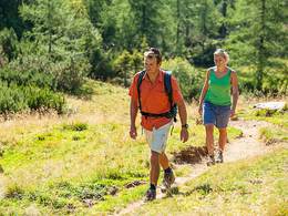
Donausteig Stage 1_N04 Obermühl - St. Martin: "Summit assault - Danube valley & Mühlviertler highland"


- culturally interesting
- Multi-day tour
Interactive elevation profile
Create PDF
Tour-Details
Paths covering:
Donaustieg-simply fabulous! Summit assault onto the Burgstall - the highest peak, which rises directly from the Danube. This stage leads us from Obermühl in the wooded Danube gorge over the Burgstall on the rural Mühlviertel plateau to the Danube village of Untermühl and again on the high plateau of the Mühlviertel to St. Martin. During the hike we discover the sunken Danube villages, the tradition of paper production, the way of the salt, the miracle of the Schwarzenberg lumber floating canal, the famous Neuhauser granite...
Recommended season:
- March
- April
- May
- June
- July
- August
- September
- October
- Multi-stage route
- Scenic
- Refreshment stops available
- Cultural/historical value
- Geological highlights
- Botanical highlights
- Faunistic highlights
- Summit route
This Donaustieg-stage starts in Obermühl. The small Danube village is located in the wooded gorge of the upper Danube at the mouth of the small mill into the mighty Danube River. The village identity remains a mystery: a historic place with unit architecture from the 1960s? From the heart of the village, we walk on a beautiful path up through the hillside forest. Remains of walls, crucifixes, a stone arch bridge, testify to the historic significance of this path... Arrived at the plateau of the Mühlviertler Highlands, we leave the forest and after a few metres reach the Tower "Burgstall". Congratulations – here we are on one of the seven Danube climbing peaks! This is the highest elevation, which rises directly from the Danube. From the viewing platform a magnificent view is presented: From the Mühlviertel, the Danube valley, the Sauwald (forest),... to even the Alps - simply fabulous! A few metres on, the summit stone of the Burgstall can be reached. The hike goes on down to the farm village of Kirchberg. On the Weiterweg (path), we walk through the atmospheric landscapes of undulating plateaus: lush meadows, laborious fields, rustic woodland, traditional farms, beautiful views,... During this walk, Farm-, field- and woodland paths alternate. At Winzberg (village) a roadway leads us back through the steep mixed woodland down to the Danube. There, a nice view over the idyllic Danube bay of Untermühl welcomes us. We follow the embankment road, cross the mouth at the large mill and are finally in the Danube River settlement of Untermühl. Only with the knowledge of the history of this place, do we recognize its diverse features - simply exciting! The short but steep climb on the jungle-like path leading to Schloss Neuhaus is an experience in itself. Initially on a romantic trek that later on an old rhinestone route, we reach finally reach the highlight: the magnificent Castle! The castle does not pride itself in its architectural details, but also tells of the nearby dismantling of the famous Neuhauser granite. From here, the stage leads on a side road leads comfortably uphill to the Donausteig-rest area "Neuhauser Platzl". After a short descent, followed by a longer climb we stand again at the attractive high plateau of the Mühlviertler Highlands. A panorama-rich Donausteig-rest area allows once again wonderful views of our surroundings! Finally we hike over the gentle ups and downs of the rural cultural landscape farm and forest paths to St. Martin. Danube valley and plateau - simply an experience!
Discover the following features with the Donausteig-diary:
-Obermühl-the sunken village!
-Donausteig-starting point "Obermühl"
-The way of the salt?
-The Grotto
-A Viking ship?
-Observation tower Burgstall-a Donausteig-Summit!
-Donaustieg-resting point "Burgstall"
-Kirchberg-simply Mühlviertel!
- ...
Download: Danube trail diary "Stage 1_N04 Obermühl St.Martin" - to follow!
Directions:From the Donausteig-starring "Obermühl" follow the road to the right of the church about 200 meters uphill. Then a right leads us to a wonderful steep walk through the forest up to the high plateau of the Mühlviertler Highlands. There, we leave the forest and are within a few metres of the viewing tower "Burgstall". The Donaustieg-resting point "Burgstall" and the summit stone follow immediately. A roadway leads after a short while down to Kirchberg, where we follow the main street heading East. At the municipal office turn left again, past the Donausteig-starting point "Kirchberg" to the building-materials trade at the end of the village. First take a left and then a right again to the sports field. Here immediately begins a prolonged forest road, on which we cross a paved road. Arriving at the edge of the forest, a farm to the left is bypassed. Finally, the farm driveway brings us to a T-junction. Take a left down to the farm at the end of the road. The walk continues largely through forest paths, occasionally meadow trails and after a short stretch of road ands at Inn Kaltenbrunn. Here on the tarmac road continue left downhill. In the next left turn continue straight ahead and reach a large farm situated in a right bend. Pass it on the left. First on meadows, later on forest paths does the walk continue through the steep forest downhill to the Danube. Turn left along the embankment, cross the bridge by the big mill and turn right down to Untermühl and to the Donausteig-starting point "Untermühl" (at the parking lot in front of the Inn Ernst). From here continue along the road heading East. After the small bridge (cyclists-barrier), the Donausteig leads left between two cabins. Then we hike on a wonderful uphill path through the forest up to the Castle Neuhaus. Arrived on top continue left on the road uphill to the Donausteig-resting point "Neuhauser Platzl", where we descend right to a little stream. Keep to the right, and arrive on a scenic meadow path up to a farm on the Falkenberg. Now on farm roads reach the T-junction in the village of Grub. Here turn first right and at the road junction in the forest turn left uphill. A dirt road leads to the next farm. There turn right downhill into the forest. The dirt roads lead us pass a large square Court to the Landshagger main street. We follow it to the right and turn right at the outskirts of St. Martin onto the village street. Shortly thereafter, we face the parish church at the Donausteig-starting point "St. Martin".
To facilitate the orientation, the Donausteig was provided with its own orientation system- descriptions found here.
Tip:
In Untermühl, in front of Castle Neuhaus and in St. Martin there are a number of informations tablets with exciting details to the hidden wonders of the region. Equipment:
On top of a personal hiking gear there are no extra requirements.Additional information:
WGD Tourismus GmbH
Lindengasse 9
4040 Linz, Austria
Tel. +43(0)732/7277-800
Fax. +43(0)732/7277-804
info@donausteig.com
Municipal office Kirchberg ob der Donau
4131 Kirchberg ob der Donau
Tel.: +43(0)7282/4601 Fax: 46015
gemeindeamt@kirchberg-donau.at
www.kirchberg-donau.at
Tourism center St. Martin
Markt 2
4113 St. Martin
Tel.: +43(0)7232/2105
gemeinde@sankt-martin.at
www.tourismus.sankt-martin.at
further information:
- Multi-day tour
- Board possible
")


Direction information: Destination
")
")
")

")


")

")
")
")
")
")
")
")
")
")
Getting there
The Starting point of this stage is located in the village center a few meters south of the Parish Church (Navigation: A‑4131 Obermühl an der Donau, Ortszentrum).
Public Transit
Obermühl can be reached relatively easy by bus. The transfer back from St. Martin is possible as well, although connections are sparse! Information on bus timetables can be found onlinde at http://www.ooevv.at .
Parking
Directly next to the Donausteig - starting point are available parking possibilites, free of charge
- Spring
- Summer
- Autumn
Please get in touch for more information.
Lindengasse 9
4040 Linz
Phone +43 732 7277 - 800
mobile +43 7282 46015
Fax machine +43 732 7277 - 804
E-Mail info@donauregion.at
Web www.donauregion.at
Web www.sankt-martin.at/Unsere_Gemeinde…
https://www.sankt-martin.at/Unsere_Gemeinde/Freizeit_Tourismus/Tourismus
Vis-à-vis users
1. The tours presented for hiking, walking, biking and road biking, mountain biking, motorbiking, horseback riding, climbing, cross-country skiing, and going on skiing and snowshoe tours etc. are to be considered non-paid tour recommendations and only serve as non-binding information. We have no intention of concluding a contract with the users of this website. The utilisation of the data does not lead to the establishment of a contract with us.
The data may only be used for private use; any commercial use is prohibited. In particular, it is not permissible to offer the data on commercially run websites, file-sharing platforms etc. or to use it to develop commercial products. Downloading data does not imply that users are granted rights to the data concerned.
The tour recommendations posted were created with utmost care; nevertheless, we assume no liability for the correctness and completeness of the information.
We point out that neither the tour recommendations included on this website nor the associated data and information were posted by us, but rather by third parties (Art. 16 Austrian E-Commerce Act). We have no influence on whether the details provided (e.g. distance, level of difficulty, change in altitude, description etc.) are authentic, correct and complete. We do not review these third-party contents. For this reason, we assume no liability for the authenticity, correctness and completeness of the information.
Construction-related measures or other influences (e.g. landslides and similar occurrences) can lead to temporary or permanent changes in a route (e.g. loss of a bridge and similar occurrences). Such occurrences can lead to part of the route or the entire route becoming impassable.
The use of the data as well as undertaking (riding, walking, taking etc.) the recommended tours or using the network of paths occurs at users’ own risk and on their authority. In particular, users themselves are responsible for the choice of route, outdoor orientation, adherence to traffic rules, supplies and equipment for tours listed in Point 1 (e.g. bicycle etc.), wearing a helmet, estimating their own fitness, recognising dangers and maintaining an appropriate velocity. We exclude ourselves from any liability whatsoever for damages, in particular accidents, that occur whilst taking part in the recommended tours.
2.Some of the tours lead over roads with normal traffic conditions. Please observe that there is an increased risk which can be avoided by means of appropriate attention and proper estimation and implementation of one’s own abilities. For this reason, please travel a route that is unfamiliar to you slowly and with special care. Pay constant attention to potential dangers and always observe traffic. Do not leave the routes featured in descriptions.
The potential use of private roads, in particular forestry roads and agricultural transport roads, can be subject to legal restrictions, which must be observed and adhered to.
The normal traffic rules apply. Each user (e.g. biker, motorbiker) is responsible for adhering to these rules and maintaining his/her bike/vehicle and its equipment (lights, brakes etc.) in good working order. Each user is also responsible for ensuring that he/she rides at a velocity that is appropriate for the conditions and his/her skill level and for maintaining sufficient distance to the rider in front. We explicitly recommend adjusting velocity to correspond to the respective field of vision, wearing a helmet, using reflective clothing (or similar) and employing bicycle lights in line with regulations.
3.Each tour requires good physical fitness as well as detailed planning. We explicitly recommend only taking the tours in the case of optimal healthiness.
We recommend that you conclude an accident and liability insurance policy. Use an onboard computer that displays the respective kilometres travelled per day and is calibrated for the front wheel.
4.Special for mountain bikers – Fair-play rules:
Mountain biking is one of the most wonderful outdoor leisure-time activities. Whilst biking or on a mountain biking tour, mountains and lakes, meadows and cabins are re-discovered in new ways. A couple of rules for fair play in the forest help to avoid conflicts whilst mountain biking.
a.Pedestrians have the right of way: We are accommodating and friendly to pedestrians and hikers. Upon encountering these fellow travellers, we alert them by using the bicycle bell and slowly overtake them. We avoid paths with heavy pedestrian traffic altogether. Take nature into account: We do not leave refuse behind.
b.The braking distance should be half of the total distance visible: We ride at a controlled pace, are ready to brake and maintain a braking distance half as long as the total distance visible, especially in curves, because we always have to count on obstacles on the path. Damage to the path, stones, branches, wood piles, grazing livestock, cattle grids, barriers, tractor-type forestry machines and authorised vehicles pose dangers that we need to be ready for.
c.Don’t drink and drive!: Do not drink alcohol when mountain biking. Take care at stop-off points (dealing with bike racks, dirty shoes or clothing).
It is obligatory to provide first aid!
d.Marked routes, closed paths and blockades: Keep to the marked routes, observe the blockades and accept that these roads are primarily for agricultural and forestry use!
Blockades can often not be avoided and are in your own interest. Biking beyond the intended path and outside of opening times is punishable and turns us into illegal bikers.
e.We are guests in the forest and behave accordingly, including vis-à-vis forestry and hunting staff. Whilst mountain biking, mobile telephones and music players are forbidden! Biking requires your full attention.
f.Avoid unnecessary noise. Out of consideration to the animals living in the wild, we only bike during full daylight. As a principle, we always wear our helmet (even when riding uphill)! Don’t forget emergency supplies: We always have a repair set and bandages along.
g.Don’t overestimate your skills: We should not overdo it when it comes to biking technique and physical fitness. Take the level of difficulty posed by the route into consideration and make a precise estimate of your experience and skills as a biker (braking, bell, lights)!
h.Close gates: We approach grazing livestock at a walking pace and close every gate behind us. We should avoid causing escape and panic reactions in the animals. Nothing stands in the way of the fun and athletic challenge in the mountains and forests!
i.Traffic rules: The general traffic rules (StVO) apply for all the mountain biking routes and we adhere to them. Our bike therefore needs to be in perfect technical condition and equipped in line with the traffic rules, including brakes, a bell and lights. We inspect and service our mountain bikes regularly anyway.
5.We assume no liability for the contents of external websites; in particular, we assume no liability for their statements and contents. Moreover, we have no influence on the design or contents of the websites to which hyperlinks on guide.oberoesterreich.at lead or from which hyperlinks lead to guide.oberoesterreich.at. There is no on-going review of websites to which hyperlinks on guide.oberoesterreich.at lead or from which hyperlinks lead to guide.oberoesterreich.at. We do not appropriate the contents of websites to which hyperlinks on guide.oberoesterreich.at lead or from which hyperlinks lead to guide.oberoesterreich.at.
Vis-à-vis bloggers
PLEASE OBSERVE:
1. Each of your tour recommendations for hiking, walking, biking and road biking, mountain biking, motorbiking, horseback riding, climbing, cross-country skiing, and going on skiing and snowshoe tours etc., along with other details and information, is free of charge. In particular regarding the correctness of the information, we assume no liability, nor do we assume any liability whatsoever for the consequences of the use of your tour recommendation by a third party (in particular by a user of this website). We do not review the tour recommendations you post, including other details and information, at any time.
We have no intention of concluding a contract with persons who post tour recommendations and/or other details and information on this website. Posting data (information) does not imply that a contract has been concluded.
By recommending a tour, we assume special responsibility vis-à-vis other athletes. Please take this responsibility seriously and describe your tour recommendation with utmost care and to the best of your knowledge and belief.
2.Your tour recommendations must therefore clearly and unambiguously include at least the following criteria and provide a sufficiently detailed description:
• Starting point
• Detailed route description
• Distance/Overall distance
• Level of difficulty
• Dangerous spots
• Average duration of trip
• Change in altitude
• Finishing point.
If possible, please provide the change in altitude.
3.When you post a tour recommendation, you give us the order to save your tour recommendation and/or the details you provide on our website and to make it/them accessible to third parties, in particular to users of this website, in the long term. We reserve the right to block or delete tour recommendations and/or other details and/or information that you post, either partially or entirely, at any time without providing a justification. Should this occur, it grants you no rights whatsoever.
Thank you for your efforts!
4. We are not responsible for the contents of external websites; in particular, we do not assume any liability for their statements or contents. Furthermore, we do not influence the design or contents of websites that can be accessed from guide.oberoesterreich.at via hyperlinks or that use hyperlinks to refer to guide.oberoesterreich.at. The websites that can be accessed from guide.oberoesterreich.at via hyperlinks or that use hyperlinks to refer to guide.oberoesterreich.at are not regularly monitored. Furthermore, we do not assume any claims to the websites that can be accessed from guide.oberoesterreich.at via hyperlinks or that use hyperlinks to refer to guide.oberoesterreich.at.
Interactive elevation profile
Create PDF
Tour-Details
Paths covering: