Donausteig Stage 4_G03 Mauthausen - Perg: „From granite art and millstones“


- culturally interesting
- Multi-day tour
Interactive elevation profile
Create PDF
Tour-Details
Paths covering:
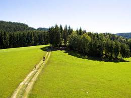
The Donausteig-simply fabulous! This stage leads us from Mauthausen along the Danube through the cultivated plains of the Machland and the panoramic hills of the Mühlviertel (region) to Perg on the northern edge of the Machland. We discover the Mauthausen art of granite , the salt road to Bohemia, the secrets of porcelain, the Perger Millstone crushers...
Recommended season:
- March
- April
- May
- June
- July
- August
- September
- October
- Multi-stage route
- Refreshment stops available
- Cultural/historical value
Seal of approval:
- Quality route according to "Österreichisches Wandergütesiegel"
Starting point for this leg of the Donausteig is Mauthausen. The Mühlviertler hills fall steeply down to the Danube. The historical market is situated on the Danube opposite the Ennsmündung (river mouth). The magnificent shore line and the lovely town centre bear witness to a wealth-generating past through toll stations, and salt and granite trade. The variety of wonderful works of granite - granite art in highest perfection is unique to Mauthausen. We start on the beautiful shore line and follow the Danube River to the old Heinrichskirche (church) at the market. Here we leave the Danube and move comfortably over partly forested hills back to the fabled Heinrichsbründl. Shortly afterwards we are further down in the cultivated Plains of the Machland: small settlements, fertile fields, peasant farms and small forest stretches dominate the landscape. On quiet back roads and rural filed paths we wander through the vastness of the Machland on the other side of the plane. The International Soldiers Cemetery here reminds us of the dark ages of history. In the rural village of Aisthofen, once an important Manor House, starts a short climb into the hills of the Mühlviertel. After a few minutes, the Donausteig-resting point "Weinbau, Gmeiner, Weinzirl" is reached - the scenic highlight of this stage! The view go far from the mystical Ötscher (mountain) in the Mostviertel to the striking Traunstein (mountain) in the Salzkammergut region. The further hilly pathway varies through open landscapes and shady woodlands. At the unusual Kalvarienbergkirche (church) of Perg, we once again arrive at the edge of the Mühlviertler hills – on a magnificent terrace the city of Perg and the Machland lie at our feets. After a short descent, we are on the main square of the historical city of Perg, formerly know due to its millstone crushers - simply fabulous!
Discover the following features with the Donausteig-diary:
-Mauthausen-the center for granite art
-Donausteig-starting point "Mauthausen"
-Granite sculpture "Monolith with a bike"
-The Enns-iron in the River
-Monument "Rollfähre"
-The salt Tower-the "traffic light" of the salt road
-A well for the world's fair
-Heinrichskirche-sanctuary for the salt merchants
- ...
Download: Donausteig-diary "Stage 4_G03 Mauthausen PERG" - yet to follow!
Directions:From the Donausteig-starting point at the shore line in Mauthausen, we follow the Heindlkai downstream through the Archway of the old master ship house. A few metres on we walk on the Vormarktstrasse (street), passing the Heinrichskirche (church). At the next major intersection, turn left onto Vormarktstrasse (street). After a few metres, a gravel road leads uphill through the forest. At the T-intersection in the village keep to the right and a few meters later follow the road left. At the intersection to the Eschenweges (path), turn right and continue up to the end of the settlement (forest edge). There a foot and later field/forest trail branches off to the left. After a short time, the Heinrichsbründl is reached. Here, we follow the asphalt road downhill and turn left at the next intersection (large Vierkanthof (farm)) in the Gutshofweg (path). After crossing the railroad tracks, continue straight across the heavily trafficked Freistädter Steet into the Kindergartenstrasse (street). The buildings of Heinrichbrunn are passed on the right. Hereafter the wide Machlandstrasse (own walking and cycling Strip) is followed left across the fields. Turn at the next junction (beginning of the settlement) first left and then right again into the Professor-Gerstmayr-Straße (street). Pass the International Soldiers Cemetery and reach the settlement Hinterholz. After a slight right turn to the left continue towards Neuhart. Follow the dirt road through the fields left after the houses in Neuhart. On the asphalt road into the forest first turn left and after a few metres on the edge of the forest (large tree image monument) turn right again. Here, we go on to the village of Althart. At the next intersection turn right and continue straight towards the East following the asphalt road. We cross the Naarnfluss and follow the dirt road at the beginning upstream, later however we cross the fields and continue to Aisthofen. There, we cross the main road at the large Chapel. Now a paved road continue uphill initially. This road quickly turns into a dirt road and guides us passed the Donausteig-Resting point „Weinbau Gmeiner, Weinzierl“ and to the rural village of Weinzierl. At the junction in the village we take the asphalt road left uphill. At the next crossing (shortly before a chapel) turn left again uphill. The road now go first up over a ridge and then into a small basin. There we turn right at the second crossing and follow the trail through woodland sand meadows passing Donausteig-viewing point. At the settlement of Zeitling turn first left and on the asphalt road keep again to the left. The small asphalt road leads in the wide arc Northeast. At the next intersection turn right and follow the road, which later turns into a narrow footpath continuing down to the cemetery of Perg. At the paved cemetery road briefly continue left uphill to the Kalvarienbergkirche (church). From there a well constructed footpath passes two beautiful Donausteig-viewing points down to the Friedhofstraße (street). Walk left downhill to Linzer Straße (street). There left and after 100 m the main square of Pergis reached with its Donausteig-starting point.
To facilitate the orientation, the Donausteig was provided with its own system of orientation - you will find the description here .
Tip:- Take a tour of the small alleys of Mauthausen -the many different details of the Granite art are just magnifcent!
- Journeys of discovery with an enjoyable stopover! This tour leads directly past the following culinary partner:
Weinbau Gmeiner in Perg
sturdy shoes. food and drink opportunites are only possible with small detours on this tour!Additional information:
WGD Tourismus GmbH
Lindengasse 9
4040 Linz, Austria
Tel. +43(0)732/7277-800
Fax. +43(0)732/7277-804
info@donausteig.com
Tourism agency Mauthausen
Heindlkai 13
4310 Mauthausen
Tel.: +43(0)7238/2243 od. 2023-0 Fax: DW-51
mauthausen@oberoesterreich.at
www.tiscover.com/mauthausen
www.mauthausen.biz
Perg marketing office
Linzerstr. 2
4320 Perg
Tel.: +43(0)7262/53150 Fax: DW 16
info@perg.at
www.stadtmarketing.perg.at
www.perg.at
further information:
- Multi-day tour
- Board possible

")


Direction information: Departure

Direction information: Destination
")
")
")
")
")
")
")

)")

")
")
")
")
")
")

")


")
")
")
Getting there
The Donausteig-starting point "Mauthausen" is located next to the Tourism office of Mautahusen on the river promenade south east of Schloss Pragstein (castle) (Navigation: A-4310 Mauthausen, Heindlkai 13).
Public Transit
Mauthausen can be reach by train or bus. A transfer back from Perg to Mauthausen is possible as well by bus and train. The bus drives directly from the Perger main square to the Mauthausener market place. Take notice that when taking the train the station are further away from their resepctive main squares. Timetables online at http://www.ooevv.at .
Parking
The market center of Mauthausen is mostly only a short period parking zone - this counts also for the parking lots in its vicinity. A parking lot free of charge is about 5 walking minutes away (directly at the Donau Bndesstrasse (main road) north west of Schloss Pragstein (castle); close to the primary school)
- Spring
- Summer
- Autumn
Please get in touch for more information.
Lindengasse 9
4040 Linz
Phone +43 732 7277 - 800
Fax machine +43 732 7277 - 804
E-Mail mauthausen@oberoesterreich.at
Web www.donauregion.at
Web www.donauregion.at/oesterreich-tour…
https://www.donauregion.at/oesterreich-tour/detail/430001323/donausteig-etappe-4-g03-mauthausen-perg-von-granitkunst-und-muehlsteinbrechern.html
Vis-à-vis users
1. The tours presented for hiking, walking, biking and road biking, mountain biking, motorbiking, horseback riding, climbing, cross-country skiing, and going on skiing and snowshoe tours etc. are to be considered non-paid tour recommendations and only serve as non-binding information. We have no intention of concluding a contract with the users of this website. The utilisation of the data does not lead to the establishment of a contract with us.
The data may only be used for private use; any commercial use is prohibited. In particular, it is not permissible to offer the data on commercially run websites, file-sharing platforms etc. or to use it to develop commercial products. Downloading data does not imply that users are granted rights to the data concerned.
The tour recommendations posted were created with utmost care; nevertheless, we assume no liability for the correctness and completeness of the information.
We point out that neither the tour recommendations included on this website nor the associated data and information were posted by us, but rather by third parties (Art. 16 Austrian E-Commerce Act). We have no influence on whether the details provided (e.g. distance, level of difficulty, change in altitude, description etc.) are authentic, correct and complete. We do not review these third-party contents. For this reason, we assume no liability for the authenticity, correctness and completeness of the information.
Construction-related measures or other influences (e.g. landslides and similar occurrences) can lead to temporary or permanent changes in a route (e.g. loss of a bridge and similar occurrences). Such occurrences can lead to part of the route or the entire route becoming impassable.
The use of the data as well as undertaking (riding, walking, taking etc.) the recommended tours or using the network of paths occurs at users’ own risk and on their authority. In particular, users themselves are responsible for the choice of route, outdoor orientation, adherence to traffic rules, supplies and equipment for tours listed in Point 1 (e.g. bicycle etc.), wearing a helmet, estimating their own fitness, recognising dangers and maintaining an appropriate velocity. We exclude ourselves from any liability whatsoever for damages, in particular accidents, that occur whilst taking part in the recommended tours.
2.Some of the tours lead over roads with normal traffic conditions. Please observe that there is an increased risk which can be avoided by means of appropriate attention and proper estimation and implementation of one’s own abilities. For this reason, please travel a route that is unfamiliar to you slowly and with special care. Pay constant attention to potential dangers and always observe traffic. Do not leave the routes featured in descriptions.
The potential use of private roads, in particular forestry roads and agricultural transport roads, can be subject to legal restrictions, which must be observed and adhered to.
The normal traffic rules apply. Each user (e.g. biker, motorbiker) is responsible for adhering to these rules and maintaining his/her bike/vehicle and its equipment (lights, brakes etc.) in good working order. Each user is also responsible for ensuring that he/she rides at a velocity that is appropriate for the conditions and his/her skill level and for maintaining sufficient distance to the rider in front. We explicitly recommend adjusting velocity to correspond to the respective field of vision, wearing a helmet, using reflective clothing (or similar) and employing bicycle lights in line with regulations.
3.Each tour requires good physical fitness as well as detailed planning. We explicitly recommend only taking the tours in the case of optimal healthiness.
We recommend that you conclude an accident and liability insurance policy. Use an onboard computer that displays the respective kilometres travelled per day and is calibrated for the front wheel.
4.Special for mountain bikers – Fair-play rules:
Mountain biking is one of the most wonderful outdoor leisure-time activities. Whilst biking or on a mountain biking tour, mountains and lakes, meadows and cabins are re-discovered in new ways. A couple of rules for fair play in the forest help to avoid conflicts whilst mountain biking.
a.Pedestrians have the right of way: We are accommodating and friendly to pedestrians and hikers. Upon encountering these fellow travellers, we alert them by using the bicycle bell and slowly overtake them. We avoid paths with heavy pedestrian traffic altogether. Take nature into account: We do not leave refuse behind.
b.The braking distance should be half of the total distance visible: We ride at a controlled pace, are ready to brake and maintain a braking distance half as long as the total distance visible, especially in curves, because we always have to count on obstacles on the path. Damage to the path, stones, branches, wood piles, grazing livestock, cattle grids, barriers, tractor-type forestry machines and authorised vehicles pose dangers that we need to be ready for.
c.Don’t drink and drive!: Do not drink alcohol when mountain biking. Take care at stop-off points (dealing with bike racks, dirty shoes or clothing).
It is obligatory to provide first aid!
d.Marked routes, closed paths and blockades: Keep to the marked routes, observe the blockades and accept that these roads are primarily for agricultural and forestry use!
Blockades can often not be avoided and are in your own interest. Biking beyond the intended path and outside of opening times is punishable and turns us into illegal bikers.
e.We are guests in the forest and behave accordingly, including vis-à-vis forestry and hunting staff. Whilst mountain biking, mobile telephones and music players are forbidden! Biking requires your full attention.
f.Avoid unnecessary noise. Out of consideration to the animals living in the wild, we only bike during full daylight. As a principle, we always wear our helmet (even when riding uphill)! Don’t forget emergency supplies: We always have a repair set and bandages along.
g.Don’t overestimate your skills: We should not overdo it when it comes to biking technique and physical fitness. Take the level of difficulty posed by the route into consideration and make a precise estimate of your experience and skills as a biker (braking, bell, lights)!
h.Close gates: We approach grazing livestock at a walking pace and close every gate behind us. We should avoid causing escape and panic reactions in the animals. Nothing stands in the way of the fun and athletic challenge in the mountains and forests!
i.Traffic rules: The general traffic rules (StVO) apply for all the mountain biking routes and we adhere to them. Our bike therefore needs to be in perfect technical condition and equipped in line with the traffic rules, including brakes, a bell and lights. We inspect and service our mountain bikes regularly anyway.
5.We assume no liability for the contents of external websites; in particular, we assume no liability for their statements and contents. Moreover, we have no influence on the design or contents of the websites to which hyperlinks on guide.oberoesterreich.at lead or from which hyperlinks lead to guide.oberoesterreich.at. There is no on-going review of websites to which hyperlinks on guide.oberoesterreich.at lead or from which hyperlinks lead to guide.oberoesterreich.at. We do not appropriate the contents of websites to which hyperlinks on guide.oberoesterreich.at lead or from which hyperlinks lead to guide.oberoesterreich.at.
Vis-à-vis bloggers
PLEASE OBSERVE:
1. Each of your tour recommendations for hiking, walking, biking and road biking, mountain biking, motorbiking, horseback riding, climbing, cross-country skiing, and going on skiing and snowshoe tours etc., along with other details and information, is free of charge. In particular regarding the correctness of the information, we assume no liability, nor do we assume any liability whatsoever for the consequences of the use of your tour recommendation by a third party (in particular by a user of this website). We do not review the tour recommendations you post, including other details and information, at any time.
We have no intention of concluding a contract with persons who post tour recommendations and/or other details and information on this website. Posting data (information) does not imply that a contract has been concluded.
By recommending a tour, we assume special responsibility vis-à-vis other athletes. Please take this responsibility seriously and describe your tour recommendation with utmost care and to the best of your knowledge and belief.
2.Your tour recommendations must therefore clearly and unambiguously include at least the following criteria and provide a sufficiently detailed description:
• Starting point
• Detailed route description
• Distance/Overall distance
• Level of difficulty
• Dangerous spots
• Average duration of trip
• Change in altitude
• Finishing point.
If possible, please provide the change in altitude.
3.When you post a tour recommendation, you give us the order to save your tour recommendation and/or the details you provide on our website and to make it/them accessible to third parties, in particular to users of this website, in the long term. We reserve the right to block or delete tour recommendations and/or other details and/or information that you post, either partially or entirely, at any time without providing a justification. Should this occur, it grants you no rights whatsoever.
Thank you for your efforts!
4. We are not responsible for the contents of external websites; in particular, we do not assume any liability for their statements or contents. Furthermore, we do not influence the design or contents of websites that can be accessed from guide.oberoesterreich.at via hyperlinks or that use hyperlinks to refer to guide.oberoesterreich.at. The websites that can be accessed from guide.oberoesterreich.at via hyperlinks or that use hyperlinks to refer to guide.oberoesterreich.at are not regularly monitored. Furthermore, we do not assume any claims to the websites that can be accessed from guide.oberoesterreich.at via hyperlinks or that use hyperlinks to refer to guide.oberoesterreich.at.
Interactive elevation profile
Create PDF
Tour-Details
Paths covering: