Donausteig Stage 1_N02 Obernzell - Niederranna "Between the Danube and the High plateau"


4040 Linz

The Donausteig-simply fabulous! On this stage, we follow the forested Durchbruchstal (valley) of the upper Danube - partly along the mighty Danube river, partly above on the rural plateau. We discover Obernzell as a jewel of the Danube, the highly demanded Passau porcelain clay, the frontier of upper bavaria, the natural jewel called the donauleiten, the importance of fishing in the middle ages...
Recommended season:
- March
- April
- May
- June
- July
- August
- September
- October
- Multi-stage route
- Scenic
- Refreshment stops available
- Cultural/historical value
- Geological highlights
- Botanical highlights
- Faunistic highlights
Seal of approval:
- Quality route according to "Österreichisches Wandergütesiegel"
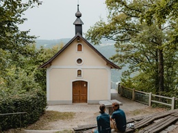
This Donausteig-stage starts in Obernzell. The historic Danube market is nestled in the wooded Gorge of the upper Danube. The beautiful village with pretty facades and narrated by prosperity through salt and kaolin...., a multi-faceted Pearl of the Danube! From Donausteig-starting point we follow the mighty Danube River along the embankment downstream for approx. 2.5 km. Passing ships and magnificent views along the road underline the fascination of the "Danube valley". At the Kohlbachmühle (mill) begins the forest climb through the protected donauleiten up to the overlying plateau of the Bavarian forest. Over the Kohlbachgraben on forest paths we reach the upper edge of the donauleiten. Arrived at the impressive high plateau undulating landscapes shaped the scenery: lush meadows, fertile fields, traditional farm hamlet, small woodlands,... simply idyllic! On farm paths we walk comfortably in a wide right curve over the rural plateau and finally return to the donauleiten. A beautiful hiking trail leads through the rustic hillside woodland of the valley side, always close to the top. A highlight is the chapel of Ebenstein with its fabulous view deep into the Danube valley - simply inspirational! In the village of Riedl, we soon encounter the high plateau, and discover the ruins of Neujochenstein. The ruins are followed by one of the most beautiful descents through the donauleiten leading towards the Danube. After a short forest path to the Dantlbach (stream) (border between Germany Austria), we descend on the wild and romantic Öttlsteig (trail): mixed forest, rare stone runs, "Alpine" climbing...an experience in itself! Some stations of the LIFE nature forest road help us recognize the natural treasures of the valley flank. Along the wide Danube, we continue to the ferry of Engelhartszell. The idyllic Frauensteig (trail), also know as smugglers way, leads steeply through mixed forest of the donauleiten up to the high plateau - part of the Mühlviertler highlands. At the top, we continue downstream along the edge of the valley side and reach the adventure highlight of this stage the fabled Penzenstein! The pulpit behind the popular forest chapel opens up wonderful views down into the danube valley, especially of Engelhartszell. Following this, we trek through the rural landscape of the plateau. Farm, field and forest roads bring us in a wide right curve passed Pühret back into the forest of the donauleiten. Now, an idyllic forest path accompanies us beside the forest edge. The rock pulpit of the Pühretsteins (rock) allows us to once again deep inspiring views - a place to ponder! After a short detour out to the plateau and then we descend slowly passed the Castle Rannariedl to the Danube. The last stretch of the trail runs along the Treppelweg to Niederranna. Between the Danube and the plateau - pur fascination!
Discover the following features with the Donausteig-diary:
-Obernzell bof fire pots and white clay
-Kaolin-the secret of porcelain
-Donausteig-starting point"Obernzell"
-Schloss Obernzell-an Episcopal summer residence
-The Danube, a water feature
-Attention shallow!
-View "Kasten & Vichtenstein"
-Crossroads- thank god!
- ...
Download: Donausteig-diary "Stage 1_N02 Obernzell Niederranna" - yet to follow
Directions:From the Donausteig-starting point "Obernzell", we follow the Danube approx. 2.5 km downstream. First along the Danube promenade, then along the Danube embankment. At the Kohlbachmühle (mill), the Danube route turns left and accompanies the Kohlbach (stream) on forest paths. After a pedestrian bridge, a short footpath leads up the right side of the Valley to the next forest road. On this keep right to the Donausteig-resting point "Kapelle Endsfelden" at the upper edge of the Donauleiten. On the rural plateau, we continue on a farm road from Endsfelden to Stollberg. Here keeping to the right we pass Hitzing and turn right after a small forest at the intersection in the direction of Krottenthal. Before this settlement turn left onto the dirt road and in a right curve continue to a Donausteig-sitting bench. As a result of crossing the asphalt street, we reach the Gasthaus (inn) Riedler Hof. There we cross as well the street and follow the road approx. 130 m. Then to the right leads a dirt road to the edge of the forest and continues downstream. Soon, the donausteig dips into the forest of the donauleiten. Passed the chapel of Ebenstein, we reach the village of Riedl. Turn right down to the castle ruins Neujochenstein (Donausteig-resting point). Then it goes through a short forest path down to the Dantlbach (stream) (border between Germany Austria). Continue straight you can reach in approx. 2 km the Jochenstein Danube power plant. The trail however continues to the left on the wild romantic Öttl-Steig (trail) downhill through the steep donauleiten to the Danube River, where a paved path brings us downstream to the ferry of Engelhartszell. At the ferry we turn left along the beautiful Frauensteig, also called smuggling route, through the woods of the steep donauleiten up to the rural plateau. Arrived at the top continue right along the forest edge to the Penzenstein (Donausteig-resting point). On the ensuing asphalt road turn right after about 360 m towards the Woods and continue through it. A side road leads straight into the village of Pühret. At the Eastern exit, turn right to the cemetery. The asphalt road passes into a magnificent forest, which brings us passed the Pühretstein and across fields in a left arc. Immediately prior to the settlement of the peasant village Dorf turn right and soon follows an idyllic walk through the woods of the Donauleiten up to the Donausteig-resting point „Bastei Schloss Rannariedl“. Now follow a short piece of road downhill, to the Castle Rannariedl and continue left on a forest road down to the Rannamühle (mill) (Donausteig-starting point) on the banks of the Danube. After the Rannabrücke (bridge) we walk right on the Treppelweg (path) of the Danube up to the Donausteig-starting point "Niederranna" in front of the Gasthof (inn) Draxler in Niederranna.
To facilitate the orientation, the Donausteig was provided with its own system of orientation - you will find the description here .
Tip:Journeys of discovery with an enjoyable stopover! This tour leads directly past the following culinary partner:
Safety guidelines:
Dangerous terrain at the Ebensteinfelsen vantage pointEquipment:
Sturdy shoesAdditional information:
WGD Tourismus GmbH
Lindengasse 9
4040 Linz, Austria
Tel. +43(0)732/7277-800
Fax. +43(0)732/7277-804
info@donausteig.com
Tourist Information Obernzell
Marktplatz 42
94130 Obernzell
Tel. +49(0)8591/9116119
Fax: +49(0)8591/9116150
tourismus@obernzell.de
www.obernzell.de
Tourism Agency Pfarrkirchen i.M.
Tel. +43(0)7285/415 Fax: 415-4
pfarrkirchen@oberoesterreich.at
www.oberoesterreich.at/pfarrkirchen
Paths covering:
further information:
- Multi-day tour
- Board possible
")
")
")


")


Direction information: Departure

Direction information: Destination
")
")
")

")
")
")
")
")

")
Getting there
Coming from the market place in Obernzell turn right the junction in front of the Castle Obernzell. Approx. 60m further on is the Donausteig-starting point on the right hand side (Navi: D‑94130 Obernzell, Schloss Obernzell).
Public Transit
Obernzell can be reached by bus. Information on timetables online at www.vlp-passau.de. A transfer back form Niederanna is possible by bus as well. However, there is no direct direct connection and bus ride can take a few hours! Information on timetables online at http://www.ooevv.at .
Parking
The city center of Obernzell is mainly a short parking zone. One can park free of charge along the walls of the castle Obernzell across from the dock of the Danube ferry or in the hostpial street.
- Suitable for groups
- Suitable for schools
- Suitable for seniors
- Suitable for single travelers
- Suitable for couples
- Suitable for children
- Spring
- Summer
- Autumn
Please get in touch for more information.
Lindengasse 9
4040 Linz
Phone +43 732 7277 - 800
mobile +49 5891 9116150
Fax machine +43 732 7277 - 804
E-Mail info@donauregion.at
Web www.donauregion.at
Web www.oberoesterreich.at/oesterreich-…
https://www.oberoesterreich.at/oesterreich-stadt-ort/detail/430001152/pfarrkirchen-im-muehlviertel.html
Vis-à-vis users
1. The tours presented for hiking, walking, biking and road biking, mountain biking, motorbiking, horseback riding, climbing, cross-country skiing, and going on skiing and snowshoe tours etc. are to be considered non-paid tour recommendations and only serve as non-binding information. We have no intention of concluding a contract with the users of this website. The utilisation of the data does not lead to the establishment of a contract with us.
The data may only be used for private use; any commercial use is prohibited. In particular, it is not permissible to offer the data on commercially run websites, file-sharing platforms etc. or to use it to develop commercial products. Downloading data does not imply that users are granted rights to the data concerned.
The tour recommendations posted were created with utmost care; nevertheless, we assume no liability for the correctness and completeness of the information.
We point out that neither the tour recommendations included on this website nor the associated data and information were posted by us, but rather by third parties (Art. 16 Austrian E-Commerce Act). We have no influence on whether the details provided (e.g. distance, level of difficulty, change in altitude, description etc.) are authentic, correct and complete. We do not review these third-party contents. For this reason, we assume no liability for the authenticity, correctness and completeness of the information.
Construction-related measures or other influences (e.g. landslides and similar occurrences) can lead to temporary or permanent changes in a route (e.g. loss of a bridge and similar occurrences). Such occurrences can lead to part of the route or the entire route becoming impassable.
The use of the data as well as undertaking (riding, walking, taking etc.) the recommended tours or using the network of paths occurs at users’ own risk and on their authority. In particular, users themselves are responsible for the choice of route, outdoor orientation, adherence to traffic rules, supplies and equipment for tours listed in Point 1 (e.g. bicycle etc.), wearing a helmet, estimating their own fitness, recognising dangers and maintaining an appropriate velocity. We exclude ourselves from any liability whatsoever for damages, in particular accidents, that occur whilst taking part in the recommended tours.
2.Some of the tours lead over roads with normal traffic conditions. Please observe that there is an increased risk which can be avoided by means of appropriate attention and proper estimation and implementation of one’s own abilities. For this reason, please travel a route that is unfamiliar to you slowly and with special care. Pay constant attention to potential dangers and always observe traffic. Do not leave the routes featured in descriptions.
The potential use of private roads, in particular forestry roads and agricultural transport roads, can be subject to legal restrictions, which must be observed and adhered to.
The normal traffic rules apply. Each user (e.g. biker, motorbiker) is responsible for adhering to these rules and maintaining his/her bike/vehicle and its equipment (lights, brakes etc.) in good working order. Each user is also responsible for ensuring that he/she rides at a velocity that is appropriate for the conditions and his/her skill level and for maintaining sufficient distance to the rider in front. We explicitly recommend adjusting velocity to correspond to the respective field of vision, wearing a helmet, using reflective clothing (or similar) and employing bicycle lights in line with regulations.
3.Each tour requires good physical fitness as well as detailed planning. We explicitly recommend only taking the tours in the case of optimal healthiness.
We recommend that you conclude an accident and liability insurance policy. Use an onboard computer that displays the respective kilometres travelled per day and is calibrated for the front wheel.
4.Special for mountain bikers – Fair-play rules:
Mountain biking is one of the most wonderful outdoor leisure-time activities. Whilst biking or on a mountain biking tour, mountains and lakes, meadows and cabins are re-discovered in new ways. A couple of rules for fair play in the forest help to avoid conflicts whilst mountain biking.
a.Pedestrians have the right of way: We are accommodating and friendly to pedestrians and hikers. Upon encountering these fellow travellers, we alert them by using the bicycle bell and slowly overtake them. We avoid paths with heavy pedestrian traffic altogether. Take nature into account: We do not leave refuse behind.
b.The braking distance should be half of the total distance visible: We ride at a controlled pace, are ready to brake and maintain a braking distance half as long as the total distance visible, especially in curves, because we always have to count on obstacles on the path. Damage to the path, stones, branches, wood piles, grazing livestock, cattle grids, barriers, tractor-type forestry machines and authorised vehicles pose dangers that we need to be ready for.
c.Don’t drink and drive!: Do not drink alcohol when mountain biking. Take care at stop-off points (dealing with bike racks, dirty shoes or clothing).
It is obligatory to provide first aid!
d.Marked routes, closed paths and blockades: Keep to the marked routes, observe the blockades and accept that these roads are primarily for agricultural and forestry use!
Blockades can often not be avoided and are in your own interest. Biking beyond the intended path and outside of opening times is punishable and turns us into illegal bikers.
e.We are guests in the forest and behave accordingly, including vis-à-vis forestry and hunting staff. Whilst mountain biking, mobile telephones and music players are forbidden! Biking requires your full attention.
f.Avoid unnecessary noise. Out of consideration to the animals living in the wild, we only bike during full daylight. As a principle, we always wear our helmet (even when riding uphill)! Don’t forget emergency supplies: We always have a repair set and bandages along.
g.Don’t overestimate your skills: We should not overdo it when it comes to biking technique and physical fitness. Take the level of difficulty posed by the route into consideration and make a precise estimate of your experience and skills as a biker (braking, bell, lights)!
h.Close gates: We approach grazing livestock at a walking pace and close every gate behind us. We should avoid causing escape and panic reactions in the animals. Nothing stands in the way of the fun and athletic challenge in the mountains and forests!
i.Traffic rules: The general traffic rules (StVO) apply for all the mountain biking routes and we adhere to them. Our bike therefore needs to be in perfect technical condition and equipped in line with the traffic rules, including brakes, a bell and lights. We inspect and service our mountain bikes regularly anyway.
5.We assume no liability for the contents of external websites; in particular, we assume no liability for their statements and contents. Moreover, we have no influence on the design or contents of the websites to which hyperlinks on guide.oberoesterreich.at lead or from which hyperlinks lead to guide.oberoesterreich.at. There is no on-going review of websites to which hyperlinks on guide.oberoesterreich.at lead or from which hyperlinks lead to guide.oberoesterreich.at. We do not appropriate the contents of websites to which hyperlinks on guide.oberoesterreich.at lead or from which hyperlinks lead to guide.oberoesterreich.at.
Vis-à-vis bloggers
PLEASE OBSERVE:
1. Each of your tour recommendations for hiking, walking, biking and road biking, mountain biking, motorbiking, horseback riding, climbing, cross-country skiing, and going on skiing and snowshoe tours etc., along with other details and information, is free of charge. In particular regarding the correctness of the information, we assume no liability, nor do we assume any liability whatsoever for the consequences of the use of your tour recommendation by a third party (in particular by a user of this website). We do not review the tour recommendations you post, including other details and information, at any time.
We have no intention of concluding a contract with persons who post tour recommendations and/or other details and information on this website. Posting data (information) does not imply that a contract has been concluded.
By recommending a tour, we assume special responsibility vis-à-vis other athletes. Please take this responsibility seriously and describe your tour recommendation with utmost care and to the best of your knowledge and belief.
2.Your tour recommendations must therefore clearly and unambiguously include at least the following criteria and provide a sufficiently detailed description:
• Starting point
• Detailed route description
• Distance/Overall distance
• Level of difficulty
• Dangerous spots
• Average duration of trip
• Change in altitude
• Finishing point.
If possible, please provide the change in altitude.
3.When you post a tour recommendation, you give us the order to save your tour recommendation and/or the details you provide on our website and to make it/them accessible to third parties, in particular to users of this website, in the long term. We reserve the right to block or delete tour recommendations and/or other details and/or information that you post, either partially or entirely, at any time without providing a justification. Should this occur, it grants you no rights whatsoever.
Thank you for your efforts!
4. We are not responsible for the contents of external websites; in particular, we do not assume any liability for their statements or contents. Furthermore, we do not influence the design or contents of websites that can be accessed from guide.oberoesterreich.at via hyperlinks or that use hyperlinks to refer to guide.oberoesterreich.at. The websites that can be accessed from guide.oberoesterreich.at via hyperlinks or that use hyperlinks to refer to guide.oberoesterreich.at are not regularly monitored. Furthermore, we do not assume any claims to the websites that can be accessed from guide.oberoesterreich.at via hyperlinks or that use hyperlinks to refer to guide.oberoesterreich.at.