R1.05 Sauwald Panorama Circuit


4040 Linz

'Sauwald – Sublime cycling with Alpine views'
Recommended season:
- March
- April
- May
- June
- July
- August
- September
- October
- Loop
- Scenic
- Refreshment stops available
- Family friendly
- Geological highlights
Fantastic highland cycle tour across the agricultural Sauwald high plateau. The rugged highlands to the south of the Upper Danube Valley inspire with mysterious woodlands, a mosaic of fields and meadows, traditional farming hamlets, an undulating landscape … and sheer endless views into the distance. The first half proceeds through a hilly landscape, the second across a panoramic mountain ridge.
Highlights:
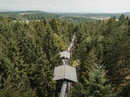
- Kopfing treetop trail (Longest treetop walk in the world, nature adventure world)
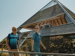
- Meditation pyramid on Etzinger Hill (architectural highlight, Alpine views)
- Sauwald panorama road (designed panoramic viewing points)
- IKUNA nature resort and nature adventure park
- Vier-Viertel-Blick (panoramic views across all four 'quarters' of Upper Austria)
A worthy starting point for this cycle circuit over the Sauwald high plateau, which provides plenty of contrasts, is the treetop trail in Kopfing. Located on a forested hilltop, it enables you to enjoy unusual perspectives into the distance from the treetops and to take in the beauty of the high plateau. Simply breath-taking! From the forested hilltop, cycle via agricultural roads down into the pretty altitude village of Kopfing – a scattered village typical of the Sauwald! In this harsh climate the land had to provide food, so any considerations of the overall appearance of the area were put to one side. On Kopfinger Straße the undulating route proceeds up to Entholz. Shortly afterwards you are immersed in the mysterious woodland areas of Sauwald. Almost flat forest paths proceed through a fantastic area of mixed woodland, past the Jungfraustein, shrouded in legend – a rocking stone and traditional ritual site! It is here that you get a sense of the atmospheric traditional (Sau)Wald forest landscape. You then enjoy a pleasurable cycle uphill on secluded side roads through the extensive Hörzinger Wald, on gently undulating terrain. Agricultural oases in the middle of the sea of woodland are a reminder of arduous land reclamation. After the valley, lush pastures, fertile fields, scattered farms, little woodlands ... dominate the route – a pure Sauwald rural idyll! From Reiting, a speedy 2 km descent to Natternbach provides a rush of speed. Incidentally, the lovely market town – also a scattered village- played a key role in the Peasants' War in Upper Austria. The altitude location and the beauty of the Sauwald give the local people a sense of pride. A short climb up to a plateau, then through a mosaic of fields to Neukirchen am Walde. The ideal, typical market square is of historic significance, and former Spättenbrunn Castle recounts a medieval sovereign rule. From the plateau, a 2.4 km pleasure-filled descent proceeds down to Willing, the lowest point (391m) of the circuit! Through the steep forest troughs of Waldbach, the route then proceeds swiftly uphill. In Hofstetten the toughest section is over – crossing secluded farmland you ride on gentle hills – partly across natural field routes – up into the altitude village of St. Agatha. The sublime ride across the rooftop of Sauwald now begins! On mellow goods roads you cycle across a hilly panoramic altitude ridge. The superb opening act is the impressive Etzinger Meditation Pyramid (642 m). Congratulations, you are standing on the highest point of the circuit! As a result, you will be inspired by the wonderful Sauwald agricultural land and breath-taking views into Mühlviertel, across the Alpine foothills to the Alps ... Pure bliss! After a short trough, in Waldkirchen am Wesen you head up to the next altitude ridge. The Sauwald High(!)plateau once again reveals its loveliest side. A highlight: a short detour to the exceptional Vier-Viertel-Blick. The 360° panoramic view provides unlimited views to all four 'quarters' of Upper Austria! A short recovery ride takes you into the forested trough area at Sittling. There then follows a 4.5 km ascent across a mountain ridge. Enchanted by the idyllic Sauwald farmland, as the elevation increases, the view becomes more expansive. In St. Aegidi you are standing at the highest point of the third altitude ridge. Congratulations! After all that climbing, the undulating descent through concealed wide open valley provides some relaxation. From Voglgrub the final climb begins, proceeding through undulating farmland and the traditional (Sau)Wald up to the treetop trail. Highland cycling – a (lofty) treat!Tip:
Journeys of discovery with an enjoyable stopover! This tour leads directly past the following culinary partner:
Safety guidelines:
The majority of this highland cycle tour uses peaceful (side) streets and asphalt goods roads. The route proceeds 1.5 km to the Jungfraustein area, and just before the treetop trail there is 800m over a forested path. Natural field path sections are available before Hofstetten (600 m) and around Hausleithen (900 m, 800 m). This means that the circuit is not really suitable for road (race) bikes. Basic gear technique is expedient for the climbing sections, while basic braking technique is required for the descents.
Signage:
To make orientation easier for you, the Danube Cycle Path circuits are designated with their own cycle guidance system. This circuit follows the "R1.05 Sauwald-Panorama-Runde" signposts.
Paths covering:
further information:
- Flatly
- Board possible
")
")
")
")
")
Public Transit
Location and getting there
How to arrive in the Danube Upper Austrian region? The fast way to your destination – by train, bus, car, boat or plane.
- Spring
- Summer
- Autumn
Please get in touch for more information.
Lindengasse 9
4040 Linz
Phone +43 732 7277 - 800
Fax machine +43 732 7277 - 804
E-Mail info@donauregion.at
Web www.donauregion.at
Vis-à-vis users
1. The tours presented for hiking, walking, biking and road biking, mountain biking, motorbiking, horseback riding, climbing, cross-country skiing, and going on skiing and snowshoe tours etc. are to be considered non-paid tour recommendations and only serve as non-binding information. We have no intention of concluding a contract with the users of this website. The utilisation of the data does not lead to the establishment of a contract with us.
The data may only be used for private use; any commercial use is prohibited. In particular, it is not permissible to offer the data on commercially run websites, file-sharing platforms etc. or to use it to develop commercial products. Downloading data does not imply that users are granted rights to the data concerned.
The tour recommendations posted were created with utmost care; nevertheless, we assume no liability for the correctness and completeness of the information.
We point out that neither the tour recommendations included on this website nor the associated data and information were posted by us, but rather by third parties (Art. 16 Austrian E-Commerce Act). We have no influence on whether the details provided (e.g. distance, level of difficulty, change in altitude, description etc.) are authentic, correct and complete. We do not review these third-party contents. For this reason, we assume no liability for the authenticity, correctness and completeness of the information.
Construction-related measures or other influences (e.g. landslides and similar occurrences) can lead to temporary or permanent changes in a route (e.g. loss of a bridge and similar occurrences). Such occurrences can lead to part of the route or the entire route becoming impassable.
The use of the data as well as undertaking (riding, walking, taking etc.) the recommended tours or using the network of paths occurs at users’ own risk and on their authority. In particular, users themselves are responsible for the choice of route, outdoor orientation, adherence to traffic rules, supplies and equipment for tours listed in Point 1 (e.g. bicycle etc.), wearing a helmet, estimating their own fitness, recognising dangers and maintaining an appropriate velocity. We exclude ourselves from any liability whatsoever for damages, in particular accidents, that occur whilst taking part in the recommended tours.
2.Some of the tours lead over roads with normal traffic conditions. Please observe that there is an increased risk which can be avoided by means of appropriate attention and proper estimation and implementation of one’s own abilities. For this reason, please travel a route that is unfamiliar to you slowly and with special care. Pay constant attention to potential dangers and always observe traffic. Do not leave the routes featured in descriptions.
The potential use of private roads, in particular forestry roads and agricultural transport roads, can be subject to legal restrictions, which must be observed and adhered to.
The normal traffic rules apply. Each user (e.g. biker, motorbiker) is responsible for adhering to these rules and maintaining his/her bike/vehicle and its equipment (lights, brakes etc.) in good working order. Each user is also responsible for ensuring that he/she rides at a velocity that is appropriate for the conditions and his/her skill level and for maintaining sufficient distance to the rider in front. We explicitly recommend adjusting velocity to correspond to the respective field of vision, wearing a helmet, using reflective clothing (or similar) and employing bicycle lights in line with regulations.
3.Each tour requires good physical fitness as well as detailed planning. We explicitly recommend only taking the tours in the case of optimal healthiness.
We recommend that you conclude an accident and liability insurance policy. Use an onboard computer that displays the respective kilometres travelled per day and is calibrated for the front wheel.
4.Special for mountain bikers – Fair-play rules:
Mountain biking is one of the most wonderful outdoor leisure-time activities. Whilst biking or on a mountain biking tour, mountains and lakes, meadows and cabins are re-discovered in new ways. A couple of rules for fair play in the forest help to avoid conflicts whilst mountain biking.
a.Pedestrians have the right of way: We are accommodating and friendly to pedestrians and hikers. Upon encountering these fellow travellers, we alert them by using the bicycle bell and slowly overtake them. We avoid paths with heavy pedestrian traffic altogether. Take nature into account: We do not leave refuse behind.
b.The braking distance should be half of the total distance visible: We ride at a controlled pace, are ready to brake and maintain a braking distance half as long as the total distance visible, especially in curves, because we always have to count on obstacles on the path. Damage to the path, stones, branches, wood piles, grazing livestock, cattle grids, barriers, tractor-type forestry machines and authorised vehicles pose dangers that we need to be ready for.
c.Don’t drink and drive!: Do not drink alcohol when mountain biking. Take care at stop-off points (dealing with bike racks, dirty shoes or clothing).
It is obligatory to provide first aid!
d.Marked routes, closed paths and blockades: Keep to the marked routes, observe the blockades and accept that these roads are primarily for agricultural and forestry use!
Blockades can often not be avoided and are in your own interest. Biking beyond the intended path and outside of opening times is punishable and turns us into illegal bikers.
e.We are guests in the forest and behave accordingly, including vis-à-vis forestry and hunting staff. Whilst mountain biking, mobile telephones and music players are forbidden! Biking requires your full attention.
f.Avoid unnecessary noise. Out of consideration to the animals living in the wild, we only bike during full daylight. As a principle, we always wear our helmet (even when riding uphill)! Don’t forget emergency supplies: We always have a repair set and bandages along.
g.Don’t overestimate your skills: We should not overdo it when it comes to biking technique and physical fitness. Take the level of difficulty posed by the route into consideration and make a precise estimate of your experience and skills as a biker (braking, bell, lights)!
h.Close gates: We approach grazing livestock at a walking pace and close every gate behind us. We should avoid causing escape and panic reactions in the animals. Nothing stands in the way of the fun and athletic challenge in the mountains and forests!
i.Traffic rules: The general traffic rules (StVO) apply for all the mountain biking routes and we adhere to them. Our bike therefore needs to be in perfect technical condition and equipped in line with the traffic rules, including brakes, a bell and lights. We inspect and service our mountain bikes regularly anyway.
5.We assume no liability for the contents of external websites; in particular, we assume no liability for their statements and contents. Moreover, we have no influence on the design or contents of the websites to which hyperlinks on guide.oberoesterreich.at lead or from which hyperlinks lead to guide.oberoesterreich.at. There is no on-going review of websites to which hyperlinks on guide.oberoesterreich.at lead or from which hyperlinks lead to guide.oberoesterreich.at. We do not appropriate the contents of websites to which hyperlinks on guide.oberoesterreich.at lead or from which hyperlinks lead to guide.oberoesterreich.at.
Vis-à-vis bloggers
PLEASE OBSERVE:
1. Each of your tour recommendations for hiking, walking, biking and road biking, mountain biking, motorbiking, horseback riding, climbing, cross-country skiing, and going on skiing and snowshoe tours etc., along with other details and information, is free of charge. In particular regarding the correctness of the information, we assume no liability, nor do we assume any liability whatsoever for the consequences of the use of your tour recommendation by a third party (in particular by a user of this website). We do not review the tour recommendations you post, including other details and information, at any time.
We have no intention of concluding a contract with persons who post tour recommendations and/or other details and information on this website. Posting data (information) does not imply that a contract has been concluded.
By recommending a tour, we assume special responsibility vis-à-vis other athletes. Please take this responsibility seriously and describe your tour recommendation with utmost care and to the best of your knowledge and belief.
2.Your tour recommendations must therefore clearly and unambiguously include at least the following criteria and provide a sufficiently detailed description:
• Starting point
• Detailed route description
• Distance/Overall distance
• Level of difficulty
• Dangerous spots
• Average duration of trip
• Change in altitude
• Finishing point.
If possible, please provide the change in altitude.
3.When you post a tour recommendation, you give us the order to save your tour recommendation and/or the details you provide on our website and to make it/them accessible to third parties, in particular to users of this website, in the long term. We reserve the right to block or delete tour recommendations and/or other details and/or information that you post, either partially or entirely, at any time without providing a justification. Should this occur, it grants you no rights whatsoever.
Thank you for your efforts!
4. We are not responsible for the contents of external websites; in particular, we do not assume any liability for their statements or contents. Furthermore, we do not influence the design or contents of websites that can be accessed from guide.oberoesterreich.at via hyperlinks or that use hyperlinks to refer to guide.oberoesterreich.at. The websites that can be accessed from guide.oberoesterreich.at via hyperlinks or that use hyperlinks to refer to guide.oberoesterreich.at are not regularly monitored. Furthermore, we do not assume any claims to the websites that can be accessed from guide.oberoesterreich.at via hyperlinks or that use hyperlinks to refer to guide.oberoesterreich.at.