On the tracks of the Waldbahn from Reichraming, bicycle tour


- Suitable for families
- culturally interesting
- Flatly
Interactive elevation profile
Create PDF
Tour-Details
Paths covering:
Bicycle tour along the Hintergebirgsradweg with slight ascents to Weißwasser and a short, steeper ascent to the Hirschkogelsattel, followd by a rapid descent to Brunnbach.
Recommended season:
- May
- June
- July
- August
- September
- October
- Loop
- Refreshment stops available
- Family friendly
- Cultural/historical value
- Geological highlights
- Botanical highlights
On the former route of the forest railway, the cycle path leads into the Reichraminger Hintergebirge, the heart of the Kalkalpen Nationalp Park. The round covers 46 adventurous kilometres, the difference in altitude is 522 metres. From the Anzenbach car park to the managed Klaushütte the route is also suitable for families with children - little incline!
From the Klaushütte you cycle along the Großer Bach to Annerlsteg and Weißwasser. We've covered 23 kilometres here. Many bikers turn back here to enjoy the return trip along the green and pristine streams once again. But if you want to do the round trip via Brunnbach, you need a little bit more condition. On almost 5 kilometres 200 meters of altitude difference to the Hirschkogelsattel have to be mastered. From there it goes for kilometres downhill to Brunnbach and further following the Plaißabach back to the Maieralm, where the round closes. We cycle back to the starting point along the already familiar path.
Directions:Vom Ausgangspunkt am Bahnhof in Reichraming radeln wir ins Ortszentrum von Reichraming. Nun geht es immer dem Reichramingbach entlang auf der Anzenbachstraße bis zum Parkplatz Anzenbach. Hier trennt sich der Weg von der öffentlichen Straße, rechts abbiegen auf die Waldbahnstraße hinein ins Hintergebirge. Ohne merkliche Steigung radeln wir zur Abzweigung Maieralm. ACHTUNG! Lass dich nicht vom Bachverlauf täuschen. Wir überqueren den Plaißabach und folgen rechts dem Großen Bach.
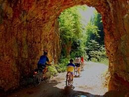
Nach ca. 1 1/4 Stunden Fahrzeit (und ca. 14,5 Kilometer ab Bahnhof Reichraming) sind wir beim einst bedeutendsten Triftbauwerk im Hintergebirge angelangt. Die Große Klause ist die älteste Klause im Hintergebirge. Für die Triftstrecke von 11,6 Kilometern bis zum Schallauer-Rechen in Reichraming brauchte das Holz eine Stunde. Zwischen den zwei Tunnels kannst du an einem nachgebauten Stück Triftsteig zur Klamm absteigen.
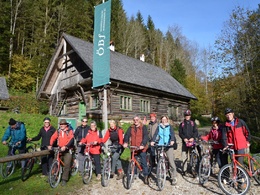
Nun trennen uns nur noch wenige Meter von der Klaushütte. 1758 erbaut diente sie den Holzknechten als Unterkunft. Heute ist sie eine ÖBf-Versorgungsstation für durstige und hungrige Radfahrer und Wanderer. Die Klaushütte ist von 1. Mai bis Mitte Oktober (je nach Witterung) jeweils Mittwoch bis Sonntag und an Feiertagen von 9 bis 19 Uhr geöffnet.
Wir radeln zwischen Bärenmauer und Teufelsgraben den Großen Bach entlang, an der Keixen vorbei, bis wir zum Eingang der Großen Schlucht kommen. Zur Rast finden wir hier am Annerlsteg eine kleine Hütte.
Tipp! Hier am Annerlsteg kann man in den Triftsteig einsteigen. Dieser gut versicherte, ca. 2 Kilometer lange Schluchtklettersteig folgt dem alten Verlauf des ehemals nur mit schmalen Holzstegen ausgestatteten Triftsteiges. Von hier aus haben die kühnen Holzknechte die Holzstämme bei Hochwasser durch die Schluchten nach Reichraming an die Enns getriftet. Der schmale, stellenweise sehr ausgesetzte Steig ist auch für Kinder und weniger Geübte gut geeignet, allerdings ist eine Klettersteig-Grundausrüstung und evtl. auch ein kurzes Sicherungsseil (für Kinder) empfehlenswert! Retour zum Ausgangspunkt am Annerlsteg gelangt man über die Forststraße und einige lange Tunnels.
Unser Radweg führt uns nun durch einige längere Tunnels der ehemaligen Waldbahn. Bei Kilometer 20 triffst du auf den Schleierfall (Wasserfall), hier fällt der Hochlachtbach zum Schwarzen Bach ab. Wir radeln weiter zwischen Hörndlmauer und Preflingkogel entlang des Schwarzen Baches bis nach Weißwasser.
Es ist kaum vorstellbar, dass hier in Weißwasser einst einige hundert Menschen lebten, die sogar eine eigene Schule und ein Geschäft hatten. Hier entstand für den Bauxit-Bergbau im Gebiet Blaberg, Prefing und Schwarza eine größere Ansiedlung für Arbeiter.
Ab Weißwasser ist ein wenig Kondition gefragt. Auf knapp 5 Kilometern sind 200 Höhenmeter zum Hirschkogelsattel zu bewältigen. Oben angelangt nützen wir die Gelegenheit zur Rast.
TIPP! Von hier aus bietet sich ein Abstecher auf die bewirtschaftete Anlaufalm an, ca. 30 Gehminuten über den Wanderweg zur Alm oder mit dem Rad rund um den Sonnberg gut 5 Kilometer zur Alm. Die Anlaufalm ist von 1. Mai bis Ende Oktober bewirtschaftet.
Vom Hirschkogelsattel geht es nun kilometerlang nur noch bergab in die kleine Ortschaft Brunnbach. Als erstes wirst du den Brunnbachstadl sehen, hier biegst du links zu und folgst der Straße weiter dem Plaißabach entlang, leicht abfallend, bis du wieder zur Maieralm kommst. Hier schließt sich der Rundweg und retour geht es am schon bekannten Weg zum Parkplatz Anzenbach und weiter nach Reichraming.
Hinweis Systemfehler: Anstiegsspitzen zwischen Kilometer 18 - 21 sind real nicht vorhanden, die Strecke führt eben durch Tunnels der ehemaligen Waldbahnstraße hindurch. (Gesamtstrecke 46 Kilometer, Anstieg ca. 522 Höhenmeter)
Tip:
Please do not forget to save the tour "offline" (top right), because the mobile phone reception in the forest wilderness of the national park is not always available.Safety guidelines:
Bitte beachten Sie: Das Radfahren und Mountainbiken im Nationalpark Gebiet ist nur in der Zeit von 15. April bis 31. Oktober 2 Stunden nach Sonnenaufgang bis 1 Stunde vor Sonnenuntergang gestattet! Ausnahme ist der Langfirst-Mountainbikeweg, hier beginnt die Bike-Saison erst ab 1. Juni. Das Radfahren und Mountainbiken ist nur auf markierten Routen gestattet. Einige Radwege sind gleichzeitig als Wanderwege oder Reitwege ausgewiesen. Rechnen Sie immer mit entgegenkommenden Wanderern oder Reitern!
Equipment:Bicycle, mountain bike, bicycle helmet, drinks and food for on the way
For hot summer days - pack swimsuits! Along the way you can descend to the stream and rest on sunny gravel banks or take a refreshing swim in the crystal clear water.
You can find more information at www.kalkalpen.at
and at www.facebook.com/waldwildnis!
Additional information:
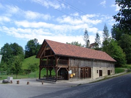
www.brunnbachschule.at/brunnbachstadl
further information:
- Flatly
- Board possible


Getting there
Via the Eisenbundesstraße (B115)
from 4400 Steyr - 4452 Ternberg - 4462 Reichraming Ortsmitte - Ortsteil Dirnbach - Parking Anzenbach
from 3335 Weyer - 4463 Großraming - 4462 Reichraming Ortsmitte - Ortsteil Dirnbach - Parking Anzenbach
Public Transit
Arrival by train to Reichraming station possible
Parking
Parking in the centre of Reichraming
Parking Schallau (free of charge)
Parking Dirnbach (free of charge)
Parking Weißenbach, toilet facilities and infopoint on site
Chargeable from 1 May - 31 October
Parking Anzenbach near Reichraming, toilet facilities and infopoint on site
- Spring
- Summer
- Autumn
Please get in touch for more information.
Vis-à-vis users
1. The tours presented for hiking, walking, biking and road biking, mountain biking, motorbiking, horseback riding, climbing, cross-country skiing, and going on skiing and snowshoe tours etc. are to be considered non-paid tour recommendations and only serve as non-binding information. We have no intention of concluding a contract with the users of this website. The utilisation of the data does not lead to the establishment of a contract with us.
The data may only be used for private use; any commercial use is prohibited. In particular, it is not permissible to offer the data on commercially run websites, file-sharing platforms etc. or to use it to develop commercial products. Downloading data does not imply that users are granted rights to the data concerned.
The tour recommendations posted were created with utmost care; nevertheless, we assume no liability for the correctness and completeness of the information.
We point out that neither the tour recommendations included on this website nor the associated data and information were posted by us, but rather by third parties (Art. 16 Austrian E-Commerce Act). We have no influence on whether the details provided (e.g. distance, level of difficulty, change in altitude, description etc.) are authentic, correct and complete. We do not review these third-party contents. For this reason, we assume no liability for the authenticity, correctness and completeness of the information.
Construction-related measures or other influences (e.g. landslides and similar occurrences) can lead to temporary or permanent changes in a route (e.g. loss of a bridge and similar occurrences). Such occurrences can lead to part of the route or the entire route becoming impassable.
The use of the data as well as undertaking (riding, walking, taking etc.) the recommended tours or using the network of paths occurs at users’ own risk and on their authority. In particular, users themselves are responsible for the choice of route, outdoor orientation, adherence to traffic rules, supplies and equipment for tours listed in Point 1 (e.g. bicycle etc.), wearing a helmet, estimating their own fitness, recognising dangers and maintaining an appropriate velocity. We exclude ourselves from any liability whatsoever for damages, in particular accidents, that occur whilst taking part in the recommended tours.
2.Some of the tours lead over roads with normal traffic conditions. Please observe that there is an increased risk which can be avoided by means of appropriate attention and proper estimation and implementation of one’s own abilities. For this reason, please travel a route that is unfamiliar to you slowly and with special care. Pay constant attention to potential dangers and always observe traffic. Do not leave the routes featured in descriptions.
The potential use of private roads, in particular forestry roads and agricultural transport roads, can be subject to legal restrictions, which must be observed and adhered to.
The normal traffic rules apply. Each user (e.g. biker, motorbiker) is responsible for adhering to these rules and maintaining his/her bike/vehicle and its equipment (lights, brakes etc.) in good working order. Each user is also responsible for ensuring that he/she rides at a velocity that is appropriate for the conditions and his/her skill level and for maintaining sufficient distance to the rider in front. We explicitly recommend adjusting velocity to correspond to the respective field of vision, wearing a helmet, using reflective clothing (or similar) and employing bicycle lights in line with regulations.
3.Each tour requires good physical fitness as well as detailed planning. We explicitly recommend only taking the tours in the case of optimal healthiness.
We recommend that you conclude an accident and liability insurance policy. Use an onboard computer that displays the respective kilometres travelled per day and is calibrated for the front wheel.
4.Special for mountain bikers – Fair-play rules:
Mountain biking is one of the most wonderful outdoor leisure-time activities. Whilst biking or on a mountain biking tour, mountains and lakes, meadows and cabins are re-discovered in new ways. A couple of rules for fair play in the forest help to avoid conflicts whilst mountain biking.
a.Pedestrians have the right of way: We are accommodating and friendly to pedestrians and hikers. Upon encountering these fellow travellers, we alert them by using the bicycle bell and slowly overtake them. We avoid paths with heavy pedestrian traffic altogether. Take nature into account: We do not leave refuse behind.
b.The braking distance should be half of the total distance visible: We ride at a controlled pace, are ready to brake and maintain a braking distance half as long as the total distance visible, especially in curves, because we always have to count on obstacles on the path. Damage to the path, stones, branches, wood piles, grazing livestock, cattle grids, barriers, tractor-type forestry machines and authorised vehicles pose dangers that we need to be ready for.
c.Don’t drink and drive!: Do not drink alcohol when mountain biking. Take care at stop-off points (dealing with bike racks, dirty shoes or clothing).
It is obligatory to provide first aid!
d.Marked routes, closed paths and blockades: Keep to the marked routes, observe the blockades and accept that these roads are primarily for agricultural and forestry use!
Blockades can often not be avoided and are in your own interest. Biking beyond the intended path and outside of opening times is punishable and turns us into illegal bikers.
e.We are guests in the forest and behave accordingly, including vis-à-vis forestry and hunting staff. Whilst mountain biking, mobile telephones and music players are forbidden! Biking requires your full attention.
f.Avoid unnecessary noise. Out of consideration to the animals living in the wild, we only bike during full daylight. As a principle, we always wear our helmet (even when riding uphill)! Don’t forget emergency supplies: We always have a repair set and bandages along.
g.Don’t overestimate your skills: We should not overdo it when it comes to biking technique and physical fitness. Take the level of difficulty posed by the route into consideration and make a precise estimate of your experience and skills as a biker (braking, bell, lights)!
h.Close gates: We approach grazing livestock at a walking pace and close every gate behind us. We should avoid causing escape and panic reactions in the animals. Nothing stands in the way of the fun and athletic challenge in the mountains and forests!
i.Traffic rules: The general traffic rules (StVO) apply for all the mountain biking routes and we adhere to them. Our bike therefore needs to be in perfect technical condition and equipped in line with the traffic rules, including brakes, a bell and lights. We inspect and service our mountain bikes regularly anyway.
5.We assume no liability for the contents of external websites; in particular, we assume no liability for their statements and contents. Moreover, we have no influence on the design or contents of the websites to which hyperlinks on guide.oberoesterreich.at lead or from which hyperlinks lead to guide.oberoesterreich.at. There is no on-going review of websites to which hyperlinks on guide.oberoesterreich.at lead or from which hyperlinks lead to guide.oberoesterreich.at. We do not appropriate the contents of websites to which hyperlinks on guide.oberoesterreich.at lead or from which hyperlinks lead to guide.oberoesterreich.at.
Vis-à-vis bloggers
PLEASE OBSERVE:
1. Each of your tour recommendations for hiking, walking, biking and road biking, mountain biking, motorbiking, horseback riding, climbing, cross-country skiing, and going on skiing and snowshoe tours etc., along with other details and information, is free of charge. In particular regarding the correctness of the information, we assume no liability, nor do we assume any liability whatsoever for the consequences of the use of your tour recommendation by a third party (in particular by a user of this website). We do not review the tour recommendations you post, including other details and information, at any time.
We have no intention of concluding a contract with persons who post tour recommendations and/or other details and information on this website. Posting data (information) does not imply that a contract has been concluded.
By recommending a tour, we assume special responsibility vis-à-vis other athletes. Please take this responsibility seriously and describe your tour recommendation with utmost care and to the best of your knowledge and belief.
2.Your tour recommendations must therefore clearly and unambiguously include at least the following criteria and provide a sufficiently detailed description:
• Starting point
• Detailed route description
• Distance/Overall distance
• Level of difficulty
• Dangerous spots
• Average duration of trip
• Change in altitude
• Finishing point.
If possible, please provide the change in altitude.
3.When you post a tour recommendation, you give us the order to save your tour recommendation and/or the details you provide on our website and to make it/them accessible to third parties, in particular to users of this website, in the long term. We reserve the right to block or delete tour recommendations and/or other details and/or information that you post, either partially or entirely, at any time without providing a justification. Should this occur, it grants you no rights whatsoever.
Thank you for your efforts!
4. We are not responsible for the contents of external websites; in particular, we do not assume any liability for their statements or contents. Furthermore, we do not influence the design or contents of websites that can be accessed from guide.oberoesterreich.at via hyperlinks or that use hyperlinks to refer to guide.oberoesterreich.at. The websites that can be accessed from guide.oberoesterreich.at via hyperlinks or that use hyperlinks to refer to guide.oberoesterreich.at are not regularly monitored. Furthermore, we do not assume any claims to the websites that can be accessed from guide.oberoesterreich.at via hyperlinks or that use hyperlinks to refer to guide.oberoesterreich.at.
Interactive elevation profile
Create PDF
Tour-Details
Paths covering: