Hutterer Alpine Meadows Circular Trail (Circular Hiking World Hinterstoder)


- Flatly
Interactive elevation profile
Create PDF
Tour-Details
Path number: 37,38
Starting place: 4573 Hinterstoder
Destination: 4573 Hinterstoder
duration: 1h 58m
length: 5,8 km
Altitude difference (uphill): 252m
Altitude difference (downhill): 254m
Lowest point: 1.362m
Highest point: 1.612m
difficulty: medium
condition: medium
panoramic view: Great panorama
Paths covering:
Gravel, Hiking trail
powered by TOURDATA
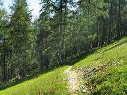
The alpine meadow trail starts at the cable car mountain station or the parking area of the Höss Toll Road on the Hutterer Plateau at approx. 1.400 m above sea level.
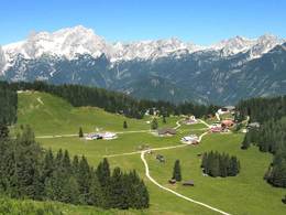
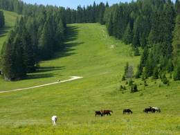
A well maintained farm road passes the bottom station of the 6-person chair lift, the Höss Express, and leads quickly uphill to the west. Enjoy your first uninterrupted and breathtaking view across the alpine panorama of the Tote Gebirge mountain range from the “Hutterer Lake”. Continue through a clear larch forest to the most western point of the area with stunning views over dolomite towers to the alpine huts of the Hutterer Alm (alpine meadow) at approx. 1.600 m above sea level. Should you decide to turn back, then follow the path leading eastwards down to the Edtbauernalm (alpine hut & meadow) or continue a level up to the alpine meadows at approx. 1.800m above sea level. From there you can take the Höss Express for a quick and easy descent back to the Hutterer Plateau. If you prefer to walk, continue along the same path back to the Hutterer Alm and follow the markings to the Edtbauernalm, along a narrow path leading through the larch forest at first, followed by the pine trees, lift areas and ski slopes crossing diagonally downhill. From the centre of the Hutterer Plateau follow the path westwards back to your starting point. Starting point: Höss Mountain Station of the gondola on the Hutterer Böden
Destination: Höss Mountain Station of the gondola on the Hutterer Böden
further information:
- Flatly
- Board possible
Details - hiking
- themed path
")
Accessibility / arrival
From the center of Hinterstoder - Leisure Park take the gondola lift to the middle station Hutterer Böden.
Parking possibility directly next to it at the large parking lot at the beginning of Hinterstoder.
Most economical season
- Spring
- Summer
- Autumn
Please get in touch for more information.

Hinterstoder 38
4573 Hinterstoder
Phone +43 7564 5263
Fax machine +43 7564 5263 - 30
E-Mail hinterstoder@pyhrn-priel.net
Web www.urlaubsregion-pyhrn-priel.at
https://www.urlaubsregion-pyhrn-priel.at
Interactive elevation profile
Create PDF
Tour-Details
Path number: 37,38
Starting place: 4573 Hinterstoder
Destination: 4573 Hinterstoder
duration: 1h 58m
length: 5,8 km
Altitude difference (uphill): 252m
Altitude difference (downhill): 254m
Lowest point: 1.362m
Highest point: 1.612m
difficulty: medium
condition: medium
panoramic view: Great panorama
Paths covering:
Gravel, Hiking trail
powered by TOURDATA