Stoder Valley Height Trail (Circular Hiking World Hinterstoder)


- Flatly
Interactive elevation profile
Create PDF
Tour-Details
Starting place: 4573 Hinterstoder
Destination: 4573 Hinterstoder
duration: 4h 43m
length: 14,2 km
Altitude difference (uphill): 591m
Altitude difference (downhill): 589m
Lowest point: 579m
Highest point: 806m
difficulty: medium
condition: medium
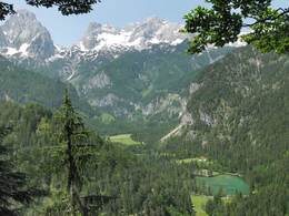
panoramic view: Great panorama
Paths covering:
Gravel, Hiking trail
powered by TOURDATA
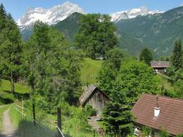
Beginning from the path next to the Hotel Poppengut you walk steeply uphill towards the toll road, which is the highest point at this stage. Pass the Fröstl farm further into the valley – cross the „Hannes Trinkl“ downhill racing track as well as the slope leading into the village.
Starting point: Relax and hiking Poppengut Hinterstoder
Destination: Relax and hiking Poppengut Hinterstoder
further information:
- Flatly
- Board possible
Details - hiking
- themed path

Accessibility / arrival
Directly from the large car park at the beginning of Hinterstoder you walk a short distance down the valley towards Vorderstoder to the relax and hiking hotel Poppengut.
- Suitable for groups
- Suitable for seniors
- Suitable for single travelers
- Suitable for friends
- Suitable for couples
- Spring
- Summer
- Autumn
Please get in touch for more information.

Hinterstoder 38
4573 Hinterstoder
Phone +43 7564 5263
E-Mail hinterstoder@pyhrn-priel.net
Web www.urlaubsregion-pyhrn-priel.at/
https://www.urlaubsregion-pyhrn-priel.at/
Interactive elevation profile
Create PDF
Tour-Details
Starting place: 4573 Hinterstoder
Destination: 4573 Hinterstoder
duration: 4h 43m
length: 14,2 km
Altitude difference (uphill): 591m
Altitude difference (downhill): 589m
Lowest point: 579m
Highest point: 806m
difficulty: medium
condition: medium
panoramic view: Great panorama
Paths covering:
Gravel, Hiking trail
powered by TOURDATA