Stoder Valley Panorama Circular Trail (Circular Hiking World Hinterstoder)


- Flatly
Interactive elevation profile
Create PDF
Tour-Details
Starting place: 4574 Hinterstoder
Destination: 4574 Hinterstoder
duration: 5h 42m
length: 15,0 km
Altitude difference (uphill): 855m
Altitude difference (downhill): 850m
Lowest point: 579m
Highest point: 818m
difficulty: medium
condition: medium
panoramic view: Great panorama
Paths covering:
Asphalt, Gravel, Hiking trail
powered by TOURDATA
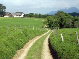
From the beginning of the Kneipp area follow the river downstream, pass Pension Prielerkreuz and cross the river Steyr over the Schachingersteig bridge. Follow the path to the Poppenberg mountain (860m), which starts on the opposite side, next to the petrol station and leads steeply uphill to the “Stoder View” viewing platform.
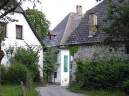
From here you can enjoy stunning views of the valley. Stay on this altitude and hike along the ridge of the mountain above the Loigis Valley to Vorderstoder. The trail leads over farm roads, forest and meadow paths passing a number of farmhouses on the way directly into the village centre of Vorderstoder. Continue on the opposite side of the village – the Hutterer side – by following the road uphill and through meadows for about 1 km. Pass the farmhouses Hackl and Bärngut before the path forks off to the right, passes the Hutstückl farmhouse and leads towards the mountain range. From the Wartegggut farmhouse at 806 m above sea level, the road leads steeply downhill back into the valley. The circular path ends gently between the Country Hotel Gressenbauer and Hotel Poppengut in Hinterstoder, only a few minutes away from your starting point. Starting point: Kneipp facilities in Hinterstoder - the big cable car parking at the rear end
Destination: Kneipp facilities in Hinterstoder - the big cable car parking at the rear end
further information:
- Flatly
- Board possible
Details - hiking
- themed path

")

")
Accessibility / arrival
From the large car park at the beginning of Hinterstoder you start the Stodertaler panoramic round.
Most economical season
- Spring
- Summer
- Autumn
Please get in touch for more information.

Hinterstoder 38
4573 Hinterstoder
Phone +43 7564 5263 - 99
Fax machine +43 7564 5263 - 30
E-Mail hinterstoder@pyhrn-priel.net
Web www.urlaubsregion-pyhrn-priel.at/
https://www.urlaubsregion-pyhrn-priel.at/
Interactive elevation profile
Create PDF
Tour-Details
Starting place: 4574 Hinterstoder
Destination: 4574 Hinterstoder
duration: 5h 42m
length: 15,0 km
Altitude difference (uphill): 855m
Altitude difference (downhill): 850m
Lowest point: 579m
Highest point: 818m
difficulty: medium
condition: medium
panoramic view: Great panorama
Paths covering:
Asphalt, Gravel, Hiking trail
powered by TOURDATA