Donausteig Stage 3_S06 Linz - Enns: „Anton Bruckner and the perfekt Landscape symphony“


4040 Linz

The Donausteif-simply fabulous! This stage leads us from Linz into the rural Linzer Basin through unique rural lanscape of the magnificent Traun-Enss-Riedellandes (region) past the Stift St. Florian to Enns. During the stage, we discover the world of Anton Bruckner, Vierkanthöfe (farms) as symbols of the farming tradition, of the most beautiful baroque abbeys, the oldest city of Austria...
Recommended season:
- March
- April
- May
- June
- July
- August
- September
- October
- Multi-stage route
- Scenic
- Refreshment stops available
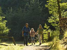
- Family friendly
- Cultural/historical value
- Suitable for strollers
The marvelous Linzer Main square is the beginning of this Donausteig-stage. With the tram we reach from here Ebelsberg, a city region of Linz on the south eastern side of the Linzer Basin. A once autonomous self, Ebelserg wrote istelf into history as strategic important crossing over teh Traunfluss (river). From the beautiful city center we begin our hike through the city until we leave it and the highway bridge behind us. Then one of the most impressive rural landscapes of Upper Austria begins: gentle hills, fertile fields, traditional orchards, the Vierkanthöfe (farms) of Upper Austria,... the Traun--Enns-Riedel country!
On old foot and field path which used alreay by Anton Bruckner, we hike over our first Riedel (hill) to the Donausteig-resting point „Ölkam“ in the same named farm village. The village emerges as a prehistoric settlement with a millenium-old puzzle. Over the fields of the next Riedel (hill) we reach farm village of Rohrbach. After a short stretch along the main road we enter on farm over the next Riedel (hill) the settlement of Leitnerberg. Through a short forest stretch we reach the Ölberg (hill) above the Stift St. Florian (abbey). Impressiveley the huge abbey lies beneath us. A short decent brungs us to the Abbey, the highlight of this Donausteig-stage! The might abbey is a jewel of baroque architecture and has many interesting details. For example, the burial site of the St. Florains and the music virtuoso Anton Bruckner. From the historic Market St. Florian we hike across the wide Ipfbachtal (valley). During the crossing views of the abbey in its dominance as a bastion of religion is presented. Past the beautiful Vierkanthöfen (farms) of the farming hamlet Weiling we reach on farm roads the next Riedel (hill). From here we see for the first time the city tower of Enss, our stage-finish point. A further comfortable hike up and down leads us to the Schloss Tillysburg (castle). The castle prides itself in its simple architecture and with its wonderful view of the Danube valley. After a short decent we cross on a secondary raod the Kristenbachtal (valley) and reach the historic farm settlement of Volkersdorf. From here we hike over our last Riedel (hill) and stand after a short forst stretch at the Donausteig-resting point "Rabenberg". Here a magnificent view of the Donausteig is possible -three different landscapes and hte historic city of Enns! After a short decent and we continue to hike along the Moosbachtal (valley) to the city of Enns. After a few minutes uphill we follow the ridge downhill to the beautiful old city of Enns, one of the oldest cities of Austria.
Discover with the Donausteig-diary the following:
-Traunfluss-Salt out of the Salzkammergut (region)
-Ebelsberg-a piece of history
-Canonball in house walls
-on the path of Anton Bruckner
-Vierkanthöfe or "of the pride of farmers"
-Donausteig-resting point„Ölkam“
-Meditation- the inner self
-Donausteig-Resting point „St. Florian“
-...
Download: - yet to follow!
Directions:From the main square in Linz take the tram line 2 to the station of Ebelsberg (Fadingerplatz). There begins our hike. We follow the main road to the south. At the big Y-junction follow the main road left uphill. In the long left bend after approx. 180 m turn right on a foot and bike path. The path transfers into the center of the cemetary (left of us) and the Reselstrasse (street). Continue straight and reach the junction with the wide Harheimerstrasse (street). We follow across from it uphill to the next junction (junction lights). There turn right uphill on the Florianerstrasse (L654) under the Highway bridge until shortly after an asphalt road branches off to the left. Here steps lead over the slope to where a magnificent pathway begins (to the left is a petrol station). At the path crossing we connect with an asphalt road. Follow it downhill. After a sharp left bend a field path leads us on a right bend over a hill to the Donausteig-resting point „Ölkam“. Cross the junction in village of „Ölkam“ and continue straight. After a right bend continue uphill to where the asphalted Siedlungstrasse turns into a field path. At the t-junction turn left downhill. Pass the transmission tower and continue along the field path further downhill to the junction with the main road in Rohrbach. The main road leads us to the village of Leitnerberg. At the Inn Rohrbäcker the Donausteig-trail branch off to the left into the Siedlungsstrasse. Shortly after we hike over a stone road uphill to the forest edge. Turn left. A few meters in the forest turn right and on a footpath reach the asphalt road in the settlement at the forest edge. Continue on it. At the next junction continue straight on the hill. At the then following junction with the Ölbergkapelle (Pavillon architecture) turn right onto the foot path downhill to the Stift St. Florian (abbey). In front of the last stair decent to the abbey church turn right. This asphalt road leads us past the Donausteig-starting point "St. Florian" and in a large loop reaches the main entrance of the Abbey St. Florian. From here along the road continue downhill and reach after a long left bend the market place of St. Florian. We leave the market place on the east side and turn straightaway right (in front of the market municipal office). Then we follow left the Leopold-Kotzmann-Strasse (street). After a short right bend cross the train tracks of the Florianerbahn, and then the Asphalt road turns into a field path. At the forest edge turn left. The foot path leads us later over a bridge of the Ipfbaches (river) to the main road L566. There turn left and then right uphill the Weilinger-Strasse. At the t-crossing turn left. We follow the street through the farm hamlet Weiling to the east. In front of the last house on the right side we turn to the right and hike uphill the s-curved Asphalt street. At the junction at the summit of the Riedels (hill) turn left. A long s-curve leads us downhill to a t-junction in Oberndorf. Hier turn left. After approx. 250 m turn right on the field path and continue around farm uphill to the Schotterstrasse. Continuing left we reach an asphalt road which we follow to the right to the Schloss Tillysburg (castle). In front of the castle begins left a footpath which encircles the castles on the east adn leads us downhill to the Inn Weberberg. Here turn right and then left and follow the asphalt road to Volkersdorf. At the T-junction turn right and on the main road until the large farm (across form the bus station). Turn left and cross the Roggenstrasse uphill. The asphalt road continues into a field path. After the crossing of the new B309 take the asphalt road at the junction into the woods. At the junctino approx. 50 m from the next farm (on the left side) a small detour leads us to the Donausteig-resting point "Rabenberg". The Donausteig continues though to the right downhill. At the valley bottom we follow the Moosbachl (stream) along the embankment. Under the highway we reach in Enss again an asphalt road. Here turn right uphill. At the next junction turn right again uphill and follow the Perlenstrasse (street) to the main road. Follow it to the left downhill. Turn right into the next road (Gürtlerstraße). After a short left curve the road leads us parallel to the main road in the direction of the old city. At the former barracks the road turns into a barracks road. At the end of the road it makes a small left turn, and straight turn right straight to the main road in the direction of the old city. Shortly along the Wienerstrasse and then left uphill to the church square. North of the parish church St. Marien through the church alley adn then left along the alley to the Bäckerturm (tower) (corner Bräuergasse). Here first left and then right past the Carl Adam Kaltenbrunner park. The Linzer Strasse leads us to the right finally to the city square of Enns.
To help you with the orientation, teh Donausteig has its own orientation system- the description can be found here .
Tip:
With the music of Anton Bruckner in the background, wil the special, rural landscape of the Traun-Enns-Riedllandes (region) become a perfekted symphony! On top of that will the hike bring through the magnificiant Stift St. Florian (abbey) new dimensions to the Donausteig.Equipment:
Sturdy shoesAdditional information:
WGD Tourismus GmbH
Lindengasse 9
4040 Linz, Austria
Tel. +43(0)732/7277-800
Fax. +43(0)732/7277-804
info@donausteig.com
Paths covering:
further information:
- Multi-day tour
- Board possible
")


Getting there
The starting point of this Stage is Linz's Main Square (Navigation: A-4020 Linz, Hauptplatz).
Public Transit
Linz can be reach by bus and tarin. At the beginnig of this trail we take from the Linz's main square the tram 2 to Ebelsberg/Ort, from where the hike begins. A transfer back form Enss to Linz is possible as well by bus and train. When taking the train take notice that the stations are further away from the respective city centers (main squares)! Information on timetables online at http://www.ooevv.at .
Parking
At the Main square there are no parking possibilites, however in its surroundings there are possibilites free of charge. Free of charge are the parking lots on the Urfahrenermarkets (market) (Approx. 15 min. walking distance take notice of the road block due to market - information at www.urfahranermarkt.at ). In a radius of around 10 walking minutes from the main square there are a number of parking possibilities.
- Suitable for pushchairs
- Suitable for families
- Spring
- Summer
- Autumn
Please get in touch for more information.
Lindengasse 9
4040 Linz
Phone +43 732 7277 - 800
Fax machine +43 732 7277 - 804
E-Mail info@donauregion.at
Web www.donauregion.at
Web www.oberoesterreich.at/oesterreich-…
https://www.oberoesterreich.at/oesterreich-stadt-ort/detail/430001046/enns.html
Vis-à-vis users
1. The tours presented for hiking, walking, biking and road biking, mountain biking, motorbiking, horseback riding, climbing, cross-country skiing, and going on skiing and snowshoe tours etc. are to be considered non-paid tour recommendations and only serve as non-binding information. We have no intention of concluding a contract with the users of this website. The utilisation of the data does not lead to the establishment of a contract with us.
The data may only be used for private use; any commercial use is prohibited. In particular, it is not permissible to offer the data on commercially run websites, file-sharing platforms etc. or to use it to develop commercial products. Downloading data does not imply that users are granted rights to the data concerned.
The tour recommendations posted were created with utmost care; nevertheless, we assume no liability for the correctness and completeness of the information.
We point out that neither the tour recommendations included on this website nor the associated data and information were posted by us, but rather by third parties (Art. 16 Austrian E-Commerce Act). We have no influence on whether the details provided (e.g. distance, level of difficulty, change in altitude, description etc.) are authentic, correct and complete. We do not review these third-party contents. For this reason, we assume no liability for the authenticity, correctness and completeness of the information.
Construction-related measures or other influences (e.g. landslides and similar occurrences) can lead to temporary or permanent changes in a route (e.g. loss of a bridge and similar occurrences). Such occurrences can lead to part of the route or the entire route becoming impassable.
The use of the data as well as undertaking (riding, walking, taking etc.) the recommended tours or using the network of paths occurs at users’ own risk and on their authority. In particular, users themselves are responsible for the choice of route, outdoor orientation, adherence to traffic rules, supplies and equipment for tours listed in Point 1 (e.g. bicycle etc.), wearing a helmet, estimating their own fitness, recognising dangers and maintaining an appropriate velocity. We exclude ourselves from any liability whatsoever for damages, in particular accidents, that occur whilst taking part in the recommended tours.
2.Some of the tours lead over roads with normal traffic conditions. Please observe that there is an increased risk which can be avoided by means of appropriate attention and proper estimation and implementation of one’s own abilities. For this reason, please travel a route that is unfamiliar to you slowly and with special care. Pay constant attention to potential dangers and always observe traffic. Do not leave the routes featured in descriptions.
The potential use of private roads, in particular forestry roads and agricultural transport roads, can be subject to legal restrictions, which must be observed and adhered to.
The normal traffic rules apply. Each user (e.g. biker, motorbiker) is responsible for adhering to these rules and maintaining his/her bike/vehicle and its equipment (lights, brakes etc.) in good working order. Each user is also responsible for ensuring that he/she rides at a velocity that is appropriate for the conditions and his/her skill level and for maintaining sufficient distance to the rider in front. We explicitly recommend adjusting velocity to correspond to the respective field of vision, wearing a helmet, using reflective clothing (or similar) and employing bicycle lights in line with regulations.
3.Each tour requires good physical fitness as well as detailed planning. We explicitly recommend only taking the tours in the case of optimal healthiness.
We recommend that you conclude an accident and liability insurance policy. Use an onboard computer that displays the respective kilometres travelled per day and is calibrated for the front wheel.
4.Special for mountain bikers – Fair-play rules:
Mountain biking is one of the most wonderful outdoor leisure-time activities. Whilst biking or on a mountain biking tour, mountains and lakes, meadows and cabins are re-discovered in new ways. A couple of rules for fair play in the forest help to avoid conflicts whilst mountain biking.
a.Pedestrians have the right of way: We are accommodating and friendly to pedestrians and hikers. Upon encountering these fellow travellers, we alert them by using the bicycle bell and slowly overtake them. We avoid paths with heavy pedestrian traffic altogether. Take nature into account: We do not leave refuse behind.
b.The braking distance should be half of the total distance visible: We ride at a controlled pace, are ready to brake and maintain a braking distance half as long as the total distance visible, especially in curves, because we always have to count on obstacles on the path. Damage to the path, stones, branches, wood piles, grazing livestock, cattle grids, barriers, tractor-type forestry machines and authorised vehicles pose dangers that we need to be ready for.
c.Don’t drink and drive!: Do not drink alcohol when mountain biking. Take care at stop-off points (dealing with bike racks, dirty shoes or clothing).
It is obligatory to provide first aid!
d.Marked routes, closed paths and blockades: Keep to the marked routes, observe the blockades and accept that these roads are primarily for agricultural and forestry use!
Blockades can often not be avoided and are in your own interest. Biking beyond the intended path and outside of opening times is punishable and turns us into illegal bikers.
e.We are guests in the forest and behave accordingly, including vis-à-vis forestry and hunting staff. Whilst mountain biking, mobile telephones and music players are forbidden! Biking requires your full attention.
f.Avoid unnecessary noise. Out of consideration to the animals living in the wild, we only bike during full daylight. As a principle, we always wear our helmet (even when riding uphill)! Don’t forget emergency supplies: We always have a repair set and bandages along.
g.Don’t overestimate your skills: We should not overdo it when it comes to biking technique and physical fitness. Take the level of difficulty posed by the route into consideration and make a precise estimate of your experience and skills as a biker (braking, bell, lights)!
h.Close gates: We approach grazing livestock at a walking pace and close every gate behind us. We should avoid causing escape and panic reactions in the animals. Nothing stands in the way of the fun and athletic challenge in the mountains and forests!
i.Traffic rules: The general traffic rules (StVO) apply for all the mountain biking routes and we adhere to them. Our bike therefore needs to be in perfect technical condition and equipped in line with the traffic rules, including brakes, a bell and lights. We inspect and service our mountain bikes regularly anyway.
5.We assume no liability for the contents of external websites; in particular, we assume no liability for their statements and contents. Moreover, we have no influence on the design or contents of the websites to which hyperlinks on guide.oberoesterreich.at lead or from which hyperlinks lead to guide.oberoesterreich.at. There is no on-going review of websites to which hyperlinks on guide.oberoesterreich.at lead or from which hyperlinks lead to guide.oberoesterreich.at. We do not appropriate the contents of websites to which hyperlinks on guide.oberoesterreich.at lead or from which hyperlinks lead to guide.oberoesterreich.at.
Vis-à-vis bloggers
PLEASE OBSERVE:
1. Each of your tour recommendations for hiking, walking, biking and road biking, mountain biking, motorbiking, horseback riding, climbing, cross-country skiing, and going on skiing and snowshoe tours etc., along with other details and information, is free of charge. In particular regarding the correctness of the information, we assume no liability, nor do we assume any liability whatsoever for the consequences of the use of your tour recommendation by a third party (in particular by a user of this website). We do not review the tour recommendations you post, including other details and information, at any time.
We have no intention of concluding a contract with persons who post tour recommendations and/or other details and information on this website. Posting data (information) does not imply that a contract has been concluded.
By recommending a tour, we assume special responsibility vis-à-vis other athletes. Please take this responsibility seriously and describe your tour recommendation with utmost care and to the best of your knowledge and belief.
2.Your tour recommendations must therefore clearly and unambiguously include at least the following criteria and provide a sufficiently detailed description:
• Starting point
• Detailed route description
• Distance/Overall distance
• Level of difficulty
• Dangerous spots
• Average duration of trip
• Change in altitude
• Finishing point.
If possible, please provide the change in altitude.
3.When you post a tour recommendation, you give us the order to save your tour recommendation and/or the details you provide on our website and to make it/them accessible to third parties, in particular to users of this website, in the long term. We reserve the right to block or delete tour recommendations and/or other details and/or information that you post, either partially or entirely, at any time without providing a justification. Should this occur, it grants you no rights whatsoever.
Thank you for your efforts!
4. We are not responsible for the contents of external websites; in particular, we do not assume any liability for their statements or contents. Furthermore, we do not influence the design or contents of websites that can be accessed from guide.oberoesterreich.at via hyperlinks or that use hyperlinks to refer to guide.oberoesterreich.at. The websites that can be accessed from guide.oberoesterreich.at via hyperlinks or that use hyperlinks to refer to guide.oberoesterreich.at are not regularly monitored. Furthermore, we do not assume any claims to the websites that can be accessed from guide.oberoesterreich.at via hyperlinks or that use hyperlinks to refer to guide.oberoesterreich.at.