Donausteig Stage 3_S05 Wilhering - Linz: „Over the Prinzensteig through the Linzer Gateway"


- culturally interesting
- Multi-day tour
Interactive elevation profile
Create PDF
Tour-Details
Paths covering:
The Donausteig-simply fabulous! This stage leads us from Wilhering in the fertile Eferding basin through the forest Donauengtal (valley) of the Linzer gateway to the Linzer basin and Linz. We discover the ancient settlement of Wilhering, one of the most beautiful monasteries of the German-speaking area, the innovative Maximillian fortress, a true capital of culture between history and modernity...
Recommended season:
- March
- April
- May
- June
- July
- August
- September
- October
- Multi-stage route
- Scenic
- Refreshment stops available
- Cultural/historical value
- Geological highlights
- Botanical highlights
- Faunistic highlights
- Insider tip
Seal of approval:
- Quality route according to "Österreichisches Wandergütesiegel"
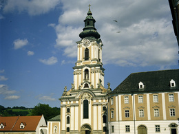
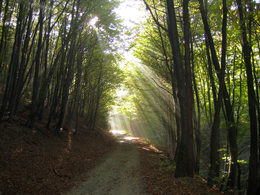
The dock of the Rollfähre (ferry) in Wilhering is the starting point for this Donausteig-stage. This former Danube bottleneck has always been an important link to the current Mühlviertel and is located on the eastern edge of the fertile Eferding basin. The Treppelweg (path) leads from here through atmospheric River forests along the Danube to the magnificent Abbey of Wilhering. Imposingly it dominates the rural peripheries behind the banks of the Danube and is a silent symbol for the reclamation of the region. The collegiate church is one of the most beautiful rococo churches of the German speaking region and is simply amazing! The forested Donauengtal (valley) of the Linzer gateway begins shortly after the abbey. The narrow Prinzensteig (path) leads us halfway up and down the steep valley flank and through the Kürnberger forest: wonderful mixed forests, low views of the Danube, an Alpine-themed track, hidden... - Donausteig-a pure experience! This beautiful section of the trail requires Surefootedness and a certain Vertigo. Later, the narrow hiking path turns into a forest path. Past the historic Donausteig-resting point „Römerturm“ we reach after a short ascent of forest Friesenegg, a rural settlement. Here, a short detour to Tower 13 of the Maximilian is recommended. The tower reveals a less well-known feature of Linz and offers fantastic views of the Alps's foothills - simply fabulous! Continue downhill in the direction of the Danube passing a residential area of the Zaubertal (valley). Just before we reach it, a beautiful forest brings us to the hidden pilgrimage chapel Maria Thal on the pulpit of a rock overlooking the Danube River. Uphill, the younger Kalvarienbergkirche (church) impress us a few meters on with its figurative representation of the twelfth Kreuzwegstation (Way of the cross station). Further uphill, through beautiful mixed forests we reach on the summit of the Freinbergs in a large park the promising Franz Josefs-Warte. Congratulations – here we stand on the highest point of this Donausteig-stage! The panorama platform opens up a wonderful look back into the idyllic Donauengtal (valley) of the Linzer gateway and across large parts of the Linzer basin - what atmospheric contrast! After leaving the park, we walk downhill through the settlements of historically important Roman Hill to the majestic Linzer Schloss (castle). There the successful symbiosis of modern and historic architecture of the Castle Museum is just a taste of the experience the "Cuture Capital of Linz" has to offer. After a short descent through the beautiful old town, we stand at the magnificent city square of Linz. The Donausteig - Simply an experience!
Discover the following features with the Donausteig-diary:
-Donausteig-starting point "Wilhering"
-Danube ferry Ottensheim Wilhering
-The Danube-a world apart
-Donausteig-starting point "Stift Wilhering"
-Stift Wilhering (abbey) - uniqueness through fire
-Kürnberger forest-a platform for the Prince
-Donausteig-resting point „Römerturm“
-Tower 13-the Maximilian fortress
- ...
Download: Donausteig-diary "Stage 3_S05 Wilhering-Linz" - Yet to follow!
Caution: Please take notice of the opening hours of the Franz Josef Warte and the gates to the Linz Castle (see diary "stage: 3_S05 Wilhering-Linz")!
Directions:From the Donausteig-starting point in Wilhering we follow the Treppelweg (path) along the Danube downstream to the Donausteig-resting point "Stift Wilhering". From there continue shortly down the Danube and then at a sharp bend follow the dirt roads back to the Abbey of Wilhering. We encircle the monastery on the West side. Past the large Abbey parking lot, we reach the main road B119. On this for approx. 400 m continue towards Linz and at the intersection with the brewery road turn to the right uphill on the Prinzenweg (path). At the next houses, the Donausteig turns left. Soon the wide frostweg (path) turns into the narrow, partially secured prinzenweg (Surefootedness and a certain head for heights are necessary here!). Halfway down the steep valley flank we walk lightly up and down along the forested Donauengtal of the Linzer gateway. Once again arriving at a forest road, we follow it to the left. Continuing past the Donausteig-Resting point „Römerturm“(A few metres away from the trail), we arrive at the leondinger road. Turn uphill to the right and after approx. 140 m turn left. On forest roads uphill we reach the Donausteig-resting point in the rural settlement of Friesenegg. The short detour to Tower 13, the fortification fortress, is achieved by turning right at the next T‑Kreuzung. The Danube track leads, however, to the left on the Frieseneggerstraße (street) in an elongated s-curve down into the Zaubertal (valley) (approx. 1.5 km) and once there on the Zaubertalstrasse (street) towards the Danube (approx. 400 m). After the Inn "Zaubertalstüberl" we cross the stream and through a forest trail we reach the pilgrimage chapel Maria Thal. Continue right up to the Kalvarienbergkirche (church). Located on the left next is a gate, through which we follow the stairs and paths to the Franz Josefs-Warte (watch tower) at the Summit of the Freinbergs. In the descent, we pass St. Barbara's Chapel and reach the Roman road at the end of the Freinberg Park. This takes us over the Römerberg downhill, past the Church of St. Martin and to the Linzer Schloss (castle). We cross the courtyard (observe the opening hours of the Castle gates!) and take the stairs, at the East Portal of the Castle, downhill to the left. Here there is also one of the two Linzer Donausteig-starting points. Straight on, we reach through the old town Linz's main square.
To facilitate the orientation, the Donausteig was provided with its own system of orientation - you will find the description here.
Caution: Please take notice of the opening hours of the Franz Josef Warte and the gates to the Linz Castle (see diary "stage: 3_S05 Wilhering-Linz")!
Tip:End this wonderful stage with a cultural evening in linz - Combine the Donausteig with culture!Equipment:
Sturdy shoes are recommended.Additional information:
WGD Tourismus GmbH
Lindengasse 9
4040 Linz, Austria
Tel. +43(0)732/7277-800
Fax. +43(0)732/7277-804
info@donausteig.com
Market Municipal Office Wilhering
Linzer Str. 14
40{3 Wilhering
Tel.: +43(0)7226/2255
Fax: +43(0)7226/3095
gemeinde@wilhering.ooe.gv.at
www.wilhering.at
Tourist Information Linz
Hauptplatz 1
4020 Linz
Tel. +43 732/7070 2009
Fax: +43 732/7070 54 2009
www.linz-tourismus.info und www.linz.at/tourismus
further information:
- Multi-day tour
- Board possible
")


Direction information: Departure
")
")
")
LinzTourismus-Müller.JPG (© TVL-Müller)")
")
Direction information: Destination
")
Getting there
From Stift Wilhering (abbey) follow the main street approx. 1km north and in the extended left bend branch of to reach the ferry Ottensheim-Wilhering. (Navigation: A-4073 Wilhering, Fähre oder Uferweg).
Public Transit
Wilhering can be reach by bus. The bus stop „Wilhering Fähre/Bundesstraße“ is closest to the Donausteig-starting point. A transfer back from Linz to Wilhering is possible by bus. Information on bus timetables online at http://www.ooevv.at .
Parking
At the ferry dock there are only a few parking possibilities. The next big parking lot (free of charge), is located at the Stift Wilhering (abbey) (approx. a 20 minute walking distance along the bike path along the main road).
- Suitable for kids (10 - 14 Year)
- Spring
- Summer
- Autumn
Please get in touch for more information.
Lindengasse 9
4040 Linz
Phone +43 732 7277 - 800
Fax machine +43 732 7277 - 804
E-Mail gemeinde@wilhering.at
Web www.donauregion.at
Web www.linztourismus.at/
https://www.linztourismus.at/
Vis-à-vis users
1. The tours presented for hiking, walking, biking and road biking, mountain biking, motorbiking, horseback riding, climbing, cross-country skiing, and going on skiing and snowshoe tours etc. are to be considered non-paid tour recommendations and only serve as non-binding information. We have no intention of concluding a contract with the users of this website. The utilisation of the data does not lead to the establishment of a contract with us.
The data may only be used for private use; any commercial use is prohibited. In particular, it is not permissible to offer the data on commercially run websites, file-sharing platforms etc. or to use it to develop commercial products. Downloading data does not imply that users are granted rights to the data concerned.
The tour recommendations posted were created with utmost care; nevertheless, we assume no liability for the correctness and completeness of the information.
We point out that neither the tour recommendations included on this website nor the associated data and information were posted by us, but rather by third parties (Art. 16 Austrian E-Commerce Act). We have no influence on whether the details provided (e.g. distance, level of difficulty, change in altitude, description etc.) are authentic, correct and complete. We do not review these third-party contents. For this reason, we assume no liability for the authenticity, correctness and completeness of the information.
Construction-related measures or other influences (e.g. landslides and similar occurrences) can lead to temporary or permanent changes in a route (e.g. loss of a bridge and similar occurrences). Such occurrences can lead to part of the route or the entire route becoming impassable.
The use of the data as well as undertaking (riding, walking, taking etc.) the recommended tours or using the network of paths occurs at users’ own risk and on their authority. In particular, users themselves are responsible for the choice of route, outdoor orientation, adherence to traffic rules, supplies and equipment for tours listed in Point 1 (e.g. bicycle etc.), wearing a helmet, estimating their own fitness, recognising dangers and maintaining an appropriate velocity. We exclude ourselves from any liability whatsoever for damages, in particular accidents, that occur whilst taking part in the recommended tours.
2.Some of the tours lead over roads with normal traffic conditions. Please observe that there is an increased risk which can be avoided by means of appropriate attention and proper estimation and implementation of one’s own abilities. For this reason, please travel a route that is unfamiliar to you slowly and with special care. Pay constant attention to potential dangers and always observe traffic. Do not leave the routes featured in descriptions.
The potential use of private roads, in particular forestry roads and agricultural transport roads, can be subject to legal restrictions, which must be observed and adhered to.
The normal traffic rules apply. Each user (e.g. biker, motorbiker) is responsible for adhering to these rules and maintaining his/her bike/vehicle and its equipment (lights, brakes etc.) in good working order. Each user is also responsible for ensuring that he/she rides at a velocity that is appropriate for the conditions and his/her skill level and for maintaining sufficient distance to the rider in front. We explicitly recommend adjusting velocity to correspond to the respective field of vision, wearing a helmet, using reflective clothing (or similar) and employing bicycle lights in line with regulations.
3.Each tour requires good physical fitness as well as detailed planning. We explicitly recommend only taking the tours in the case of optimal healthiness.
We recommend that you conclude an accident and liability insurance policy. Use an onboard computer that displays the respective kilometres travelled per day and is calibrated for the front wheel.
4.Special for mountain bikers – Fair-play rules:
Mountain biking is one of the most wonderful outdoor leisure-time activities. Whilst biking or on a mountain biking tour, mountains and lakes, meadows and cabins are re-discovered in new ways. A couple of rules for fair play in the forest help to avoid conflicts whilst mountain biking.
a.Pedestrians have the right of way: We are accommodating and friendly to pedestrians and hikers. Upon encountering these fellow travellers, we alert them by using the bicycle bell and slowly overtake them. We avoid paths with heavy pedestrian traffic altogether. Take nature into account: We do not leave refuse behind.
b.The braking distance should be half of the total distance visible: We ride at a controlled pace, are ready to brake and maintain a braking distance half as long as the total distance visible, especially in curves, because we always have to count on obstacles on the path. Damage to the path, stones, branches, wood piles, grazing livestock, cattle grids, barriers, tractor-type forestry machines and authorised vehicles pose dangers that we need to be ready for.
c.Don’t drink and drive!: Do not drink alcohol when mountain biking. Take care at stop-off points (dealing with bike racks, dirty shoes or clothing).
It is obligatory to provide first aid!
d.Marked routes, closed paths and blockades: Keep to the marked routes, observe the blockades and accept that these roads are primarily for agricultural and forestry use!
Blockades can often not be avoided and are in your own interest. Biking beyond the intended path and outside of opening times is punishable and turns us into illegal bikers.
e.We are guests in the forest and behave accordingly, including vis-à-vis forestry and hunting staff. Whilst mountain biking, mobile telephones and music players are forbidden! Biking requires your full attention.
f.Avoid unnecessary noise. Out of consideration to the animals living in the wild, we only bike during full daylight. As a principle, we always wear our helmet (even when riding uphill)! Don’t forget emergency supplies: We always have a repair set and bandages along.
g.Don’t overestimate your skills: We should not overdo it when it comes to biking technique and physical fitness. Take the level of difficulty posed by the route into consideration and make a precise estimate of your experience and skills as a biker (braking, bell, lights)!
h.Close gates: We approach grazing livestock at a walking pace and close every gate behind us. We should avoid causing escape and panic reactions in the animals. Nothing stands in the way of the fun and athletic challenge in the mountains and forests!
i.Traffic rules: The general traffic rules (StVO) apply for all the mountain biking routes and we adhere to them. Our bike therefore needs to be in perfect technical condition and equipped in line with the traffic rules, including brakes, a bell and lights. We inspect and service our mountain bikes regularly anyway.
5.We assume no liability for the contents of external websites; in particular, we assume no liability for their statements and contents. Moreover, we have no influence on the design or contents of the websites to which hyperlinks on guide.oberoesterreich.at lead or from which hyperlinks lead to guide.oberoesterreich.at. There is no on-going review of websites to which hyperlinks on guide.oberoesterreich.at lead or from which hyperlinks lead to guide.oberoesterreich.at. We do not appropriate the contents of websites to which hyperlinks on guide.oberoesterreich.at lead or from which hyperlinks lead to guide.oberoesterreich.at.
Vis-à-vis bloggers
PLEASE OBSERVE:
1. Each of your tour recommendations for hiking, walking, biking and road biking, mountain biking, motorbiking, horseback riding, climbing, cross-country skiing, and going on skiing and snowshoe tours etc., along with other details and information, is free of charge. In particular regarding the correctness of the information, we assume no liability, nor do we assume any liability whatsoever for the consequences of the use of your tour recommendation by a third party (in particular by a user of this website). We do not review the tour recommendations you post, including other details and information, at any time.
We have no intention of concluding a contract with persons who post tour recommendations and/or other details and information on this website. Posting data (information) does not imply that a contract has been concluded.
By recommending a tour, we assume special responsibility vis-à-vis other athletes. Please take this responsibility seriously and describe your tour recommendation with utmost care and to the best of your knowledge and belief.
2.Your tour recommendations must therefore clearly and unambiguously include at least the following criteria and provide a sufficiently detailed description:
• Starting point
• Detailed route description
• Distance/Overall distance
• Level of difficulty
• Dangerous spots
• Average duration of trip
• Change in altitude
• Finishing point.
If possible, please provide the change in altitude.
3.When you post a tour recommendation, you give us the order to save your tour recommendation and/or the details you provide on our website and to make it/them accessible to third parties, in particular to users of this website, in the long term. We reserve the right to block or delete tour recommendations and/or other details and/or information that you post, either partially or entirely, at any time without providing a justification. Should this occur, it grants you no rights whatsoever.
Thank you for your efforts!
4. We are not responsible for the contents of external websites; in particular, we do not assume any liability for their statements or contents. Furthermore, we do not influence the design or contents of websites that can be accessed from guide.oberoesterreich.at via hyperlinks or that use hyperlinks to refer to guide.oberoesterreich.at. The websites that can be accessed from guide.oberoesterreich.at via hyperlinks or that use hyperlinks to refer to guide.oberoesterreich.at are not regularly monitored. Furthermore, we do not assume any claims to the websites that can be accessed from guide.oberoesterreich.at via hyperlinks or that use hyperlinks to refer to guide.oberoesterreich.at.
Interactive elevation profile
Create PDF
Tour-Details
Paths covering: