Kulturwanderweg Nr. 05


- Suitable for families
- culturally interesting
- Flatly
- Possible accommodation
Interactive elevation profile
Create PDF
Tour-Details
Starting place: 4294 St. Leonhard bei Freistadt
Destination: 4294 St. Leonhard bei Freistadt
duration: 2h 30m
length: 6,8 km
Altitude difference (uphill): 400m
Altitude difference (downhill): 402m
Lowest point: 633m
Highest point: 881m
difficulty: medium
condition: medium
panoramic view: Great panorama
Paths covering:
Hiking trail
powered by TOURDATA
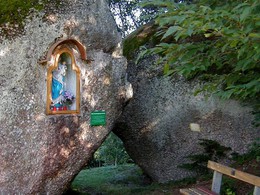
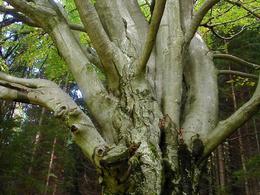
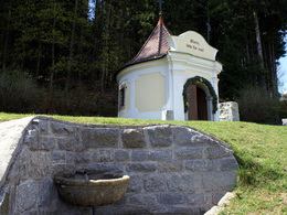
This popular circular hiking trail leads through the south-western part of our municipality. Hardly any other hiking trail offers so many interesting sights, scenic beauty, cultural and historical treasures as this one. During the hike, you will come to the "Blind Cross", the "Doomsday Stones", the "Gypsy Beech", the "Herzogreitherfelsen Viewpoint", the "Zehentkasten", the "Ulanen Kreuzstöckl", the "Nagelkreuz", the "Susi Wallner Observatory", the "Eidechsenstein" and the "Bründlkapelle". Please note: Keys for the Susi Wallner lookout point are available at the inns in the village centre.
Refreshment stops in the village centre - GH Schwarz (closed on Mondays), GH Janko (closed on Tuesdays and Mondays), Café Konditorei Honeder.
Refreshment stops in the village centre - GH Schwarz (closed on Mondays), GH Janko (closed on Tuesdays and Mondays), Café Konditorei Honeder.
Starting point: The start and finish point is in front of the municipal office. A large overview board provides extensive information.
further information:
- Flatly
- Possible accommodation
- Board possible
Details - hiking
- themed path
The culture trail can be hiked at any time.
Accessibility / arrival
by car:
A7 Mühlkreisautobahn direction Freistadt - B124 Königswiesener Straße - left onto L1472 Gutauer Straße to St. Leonhard
- Suitable for groups
- Suitable for seniors
- Suitable for single travelers
- Suitable for families
- Suitable for friends
- Suitable for couples
- Suitable for children
- Spring
- Summer
- Autumn
Please get in touch for more information.
Hauptstraße 9
4294 St. Leonhard bei Freistadt
Phone +43 7952 8255
E-Mail gemeinde@st-leonhard.ooe.gv.at
Web www.stleonhard.at
http://www.stleonhard.at
Interactive elevation profile
Create PDF
Tour-Details
Starting place: 4294 St. Leonhard bei Freistadt
Destination: 4294 St. Leonhard bei Freistadt
duration: 2h 30m
length: 6,8 km
Altitude difference (uphill): 400m
Altitude difference (downhill): 402m
Lowest point: 633m
Highest point: 881m
difficulty: medium
condition: medium
panoramic view: Great panorama
Paths covering:
Hiking trail
powered by TOURDATA