St. Martin i.M./Kleinzell i.M.: Der steinige Weg (“The Rocky Road”)


- All weather
- culturally interesting
- Flatly
Interactive elevation profile
Create PDF
Tour-Details
Paths covering:
Partenstein power plant - Ebenmühle - Kleinzell – Resilacke natural swimming bath - Granite World of Experience - Neuhaus Castle - Untermühl
Quality of experience: ******
Recommended season:
- April
- May
- June
- July
- August
- September
- October
Properties:
- Loop
- Scenic
- Refreshment stops available
- Cultural/historical value
- Geological highlights
- Insider tip
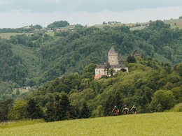
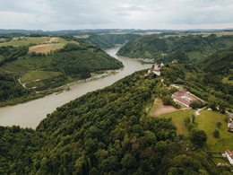
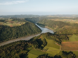
From Untermühl you follow the asphalt road along Große Mühl to Partenstein reservoir power station. Austria’s first big water plant started operating in 1924. The water is transported underground from the reservoir in Neufelden to the power plant (7km). The pipeline drops by 176m from the surge tank to the turbine house. Just before the iron bridge across Große Mühl River a trail branches off to the left. Now we follow Große Mühl River upstream on gravel and forestry trails to Ebenmühle Mill. We cross the river there and take a left turn into a forest path immediately after the bridge. After a steep uphill section in the forest we get to the village of Kleinzell on country lanes. After a well-deserved break at the local guesthouse we continue to the Alpine chain eastwards until we get to Resilacke natural swimming bath (great views en route). The trail leads downhill to Dießenbach Brook and to the Neuhaus granite quarries. We take a left turn where the brook infiltrates the earth and conquer a brief uphill section to the granite village of Plöcking. We follow the stone theme trail. At the lower end we take a left turn and hike to Neuhaus Castle. We follow Jagasteig Trail through the Schlossberg Neuhaus nature reserve to get down to our starting point in Untermühl an der Donau.
Directions:
Von Untermühl geht’s auf der asphaltierten Straße entlang der Großen Mühl zum Speicherkraftwerk Partenstein (Das monumentale Bauwerk ist 1924 als erste Großwasseranlage Österreichs in Betrieb gegangen. Das Mühlwasser wird unterirdisch vom ca. 7 km entfernten Stausee in Neufelden zum Kraftwerk geleitet. Die Wasserfallhöhe der Rohrleitung vom Wasserschloss zum Turbinenhaus beträgt 176m). Vor der eisernen Brücke über die Große Mühl zweigt der Weg links ab. Nun folgen wir der Großen Mühl flussaufwärts auf Schotter- und Waldwegen bis zur Ebenmühle. Dort überqueren wir den Fluss und zweigen unmittelbar nach der Brücke links in den Waldsteig ab. Nach dem steilen Anstieg im Wald gelangen wird auf Feldwegen zum Ort Kleinzell. Nach einer wohlverdienten Stärkung im örtlichen Gasthof wandern wir bei herrlicher Aussicht bis zur Alpenkette in östlicher Richtung zum Naturbad Resilacke. Immer wieder leicht abfallend kommen wir zum Dießenbach und zu den Neuhauser Granitsteinbrüchen. An der Versickerung des Baches zweigen wir links ab und bewältigen einen kurzen Anstieg ins Granitdorf Plöcking. In der Erlebniswelt Granit. Wir folgen dem Natursteinlehrpfad. Am unteren Ende zweigen wir links in die ehemalige „Feldbahn“ ein und wandern bis zum Schloss Neuhaus. Durchs Naturschutzgebiet „Schlossberg Neuhaus“ gelangen wir am sogenannten „Jagasteig“ wieder hinab zum Ausgangspunkt Untermühl an der Donau.
Tip:
Resilacke Natural Swimming Bath:
The former quarry invites to enjoying a bath; natural sunbathing lawns; beach volleyball court
Granite World of Experience:
The Nature Trail on Stones features more than 160 exhibits and is the biggest of its kind in Europe. Unique is its geological grouping that includes all regions of Austria. Main emphasis is on granite stones from the granite plateau (Mühlviertel, Waldviertel, Sauwald). Hammerhütte holds a small museum. A historic quarry at the end of the trail is the setting of the impressive ARENA GRANIT natural amphitheatre. Tiers are made from granite rocks and the natural stage with wild-romantic rock faces in the backdrop is the setting for open air events in the summer months. Guided tours are offered.
Granite as Construction Material:
For centuries the fine and almost white Neuhaus granite has been extracted in the region. Attentive hikers will notice numerous doors, water feeders, fountains, stairs and columns.
Safety guidelines:
Please mind blasting signal in the quarry area – a notice board is at the hiking trail!
Equipment:
Sturdy boots – in humid weather conditions it might be slippery on rocky trail sections.
Additional information:
St. Martin Tourist Board
Markt 2
4113 St. Martin
Tel.: 0043(0)7232/2105
E-mail: gemeinde@sankt-martin.at
www.tourismus.sankt-martin.at
further information:
- Flatly
- Board possible
")

")
")

")


")
")


")
")
Getting there
St. Martin:
By car:
Coming from Vienna/Linz: on the B127 (25km from Linz). “Linz-Urfahr” autobahn exit, then towards Ottensheim-Rohrbach.
Coming from Passau: Cross the Danube near Aschach and your holidays in St. Martin start (8km from Aschach, 15km from Eferding).
Coming from the North: Ride along B127 towards Linz, take a right turn towards St. Martin after 23km
By train:
Take Mühlkreisbahn trains from Linz/Urfahr and get off at Gerling train station or Neuhaus/Niederwaldkirchen train station. Train information: www.oebb.at
Direct bus connection from Linz to St. Martin.
Central bus information: www.postbus.at
By boat:
From Linz or Passau you can take a boat to Neuhaus/Untermühl landing stage. www.donauschiffahrt.de
Neuhaus/Untermühl boat landing stage (directly at the starting point).
Untermühl an der Donau, Granitdorf Plöcking
Boat – Neuhaus/Untermühl landing stage www.donauschiffahrt.de
Public Transit
Schiff - Anlegestelle Neuhaus/Untermühl www.donauschiffahrt.de
Mühlkreisbahn bis zur Haltestelle Kleinzell
Parking
Untermühl an der Donau, Granitdorf Plöcking oder Ortszentrum Kleinzell
- All weather
- Suitable for groups
- Suitable for seniors
- Suitable for single travelers
- Suitable for friends
- Suitable for couples
- Spring
- Summer
- Autumn
Please get in touch for more information.
Lindengasse 9
4040 Linz
Phone +43 732 7277 - 800
Fax machine +43 732 7277 - 804
E-Mail gemeindeamt@sankt-martin.at
Web www.donauregion.at
http://www.donauregion.at
Vis-à-vis users
1. The tours presented for hiking, walking, biking and road biking, mountain biking, motorbiking, horseback riding, climbing, cross-country skiing, and going on skiing and snowshoe tours etc. are to be considered non-paid tour recommendations and only serve as non-binding information. We have no intention of concluding a contract with the users of this website. The utilisation of the data does not lead to the establishment of a contract with us.
The data may only be used for private use; any commercial use is prohibited. In particular, it is not permissible to offer the data on commercially run websites, file-sharing platforms etc. or to use it to develop commercial products. Downloading data does not imply that users are granted rights to the data concerned.
The tour recommendations posted were created with utmost care; nevertheless, we assume no liability for the correctness and completeness of the information.
We point out that neither the tour recommendations included on this website nor the associated data and information were posted by us, but rather by third parties (Art. 16 Austrian E-Commerce Act). We have no influence on whether the details provided (e.g. distance, level of difficulty, change in altitude, description etc.) are authentic, correct and complete. We do not review these third-party contents. For this reason, we assume no liability for the authenticity, correctness and completeness of the information.
Construction-related measures or other influences (e.g. landslides and similar occurrences) can lead to temporary or permanent changes in a route (e.g. loss of a bridge and similar occurrences). Such occurrences can lead to part of the route or the entire route becoming impassable.
The use of the data as well as undertaking (riding, walking, taking etc.) the recommended tours or using the network of paths occurs at users’ own risk and on their authority. In particular, users themselves are responsible for the choice of route, outdoor orientation, adherence to traffic rules, supplies and equipment for tours listed in Point 1 (e.g. bicycle etc.), wearing a helmet, estimating their own fitness, recognising dangers and maintaining an appropriate velocity. We exclude ourselves from any liability whatsoever for damages, in particular accidents, that occur whilst taking part in the recommended tours.
2.Some of the tours lead over roads with normal traffic conditions. Please observe that there is an increased risk which can be avoided by means of appropriate attention and proper estimation and implementation of one’s own abilities. For this reason, please travel a route that is unfamiliar to you slowly and with special care. Pay constant attention to potential dangers and always observe traffic. Do not leave the routes featured in descriptions.
The potential use of private roads, in particular forestry roads and agricultural transport roads, can be subject to legal restrictions, which must be observed and adhered to.
The normal traffic rules apply. Each user (e.g. biker, motorbiker) is responsible for adhering to these rules and maintaining his/her bike/vehicle and its equipment (lights, brakes etc.) in good working order. Each user is also responsible for ensuring that he/she rides at a velocity that is appropriate for the conditions and his/her skill level and for maintaining sufficient distance to the rider in front. We explicitly recommend adjusting velocity to correspond to the respective field of vision, wearing a helmet, using reflective clothing (or similar) and employing bicycle lights in line with regulations.
3.Each tour requires good physical fitness as well as detailed planning. We explicitly recommend only taking the tours in the case of optimal healthiness.
We recommend that you conclude an accident and liability insurance policy. Use an onboard computer that displays the respective kilometres travelled per day and is calibrated for the front wheel.
4.Special for mountain bikers – Fair-play rules:
Mountain biking is one of the most wonderful outdoor leisure-time activities. Whilst biking or on a mountain biking tour, mountains and lakes, meadows and cabins are re-discovered in new ways. A couple of rules for fair play in the forest help to avoid conflicts whilst mountain biking.
a.Pedestrians have the right of way: We are accommodating and friendly to pedestrians and hikers. Upon encountering these fellow travellers, we alert them by using the bicycle bell and slowly overtake them. We avoid paths with heavy pedestrian traffic altogether. Take nature into account: We do not leave refuse behind.
b.The braking distance should be half of the total distance visible: We ride at a controlled pace, are ready to brake and maintain a braking distance half as long as the total distance visible, especially in curves, because we always have to count on obstacles on the path. Damage to the path, stones, branches, wood piles, grazing livestock, cattle grids, barriers, tractor-type forestry machines and authorised vehicles pose dangers that we need to be ready for.
c.Don’t drink and drive!: Do not drink alcohol when mountain biking. Take care at stop-off points (dealing with bike racks, dirty shoes or clothing).
It is obligatory to provide first aid!
d.Marked routes, closed paths and blockades: Keep to the marked routes, observe the blockades and accept that these roads are primarily for agricultural and forestry use!
Blockades can often not be avoided and are in your own interest. Biking beyond the intended path and outside of opening times is punishable and turns us into illegal bikers.
e.We are guests in the forest and behave accordingly, including vis-à-vis forestry and hunting staff. Whilst mountain biking, mobile telephones and music players are forbidden! Biking requires your full attention.
f.Avoid unnecessary noise. Out of consideration to the animals living in the wild, we only bike during full daylight. As a principle, we always wear our helmet (even when riding uphill)! Don’t forget emergency supplies: We always have a repair set and bandages along.
g.Don’t overestimate your skills: We should not overdo it when it comes to biking technique and physical fitness. Take the level of difficulty posed by the route into consideration and make a precise estimate of your experience and skills as a biker (braking, bell, lights)!
h.Close gates: We approach grazing livestock at a walking pace and close every gate behind us. We should avoid causing escape and panic reactions in the animals. Nothing stands in the way of the fun and athletic challenge in the mountains and forests!
i.Traffic rules: The general traffic rules (StVO) apply for all the mountain biking routes and we adhere to them. Our bike therefore needs to be in perfect technical condition and equipped in line with the traffic rules, including brakes, a bell and lights. We inspect and service our mountain bikes regularly anyway.
5.We assume no liability for the contents of external websites; in particular, we assume no liability for their statements and contents. Moreover, we have no influence on the design or contents of the websites to which hyperlinks on guide.oberoesterreich.at lead or from which hyperlinks lead to guide.oberoesterreich.at. There is no on-going review of websites to which hyperlinks on guide.oberoesterreich.at lead or from which hyperlinks lead to guide.oberoesterreich.at. We do not appropriate the contents of websites to which hyperlinks on guide.oberoesterreich.at lead or from which hyperlinks lead to guide.oberoesterreich.at.
Vis-à-vis bloggers
PLEASE OBSERVE:
1. Each of your tour recommendations for hiking, walking, biking and road biking, mountain biking, motorbiking, horseback riding, climbing, cross-country skiing, and going on skiing and snowshoe tours etc., along with other details and information, is free of charge. In particular regarding the correctness of the information, we assume no liability, nor do we assume any liability whatsoever for the consequences of the use of your tour recommendation by a third party (in particular by a user of this website). We do not review the tour recommendations you post, including other details and information, at any time.
We have no intention of concluding a contract with persons who post tour recommendations and/or other details and information on this website. Posting data (information) does not imply that a contract has been concluded.
By recommending a tour, we assume special responsibility vis-à-vis other athletes. Please take this responsibility seriously and describe your tour recommendation with utmost care and to the best of your knowledge and belief.
2.Your tour recommendations must therefore clearly and unambiguously include at least the following criteria and provide a sufficiently detailed description:
• Starting point
• Detailed route description
• Distance/Overall distance
• Level of difficulty
• Dangerous spots
• Average duration of trip
• Change in altitude
• Finishing point.
If possible, please provide the change in altitude.
3.When you post a tour recommendation, you give us the order to save your tour recommendation and/or the details you provide on our website and to make it/them accessible to third parties, in particular to users of this website, in the long term. We reserve the right to block or delete tour recommendations and/or other details and/or information that you post, either partially or entirely, at any time without providing a justification. Should this occur, it grants you no rights whatsoever.
Thank you for your efforts!
4. We are not responsible for the contents of external websites; in particular, we do not assume any liability for their statements or contents. Furthermore, we do not influence the design or contents of websites that can be accessed from guide.oberoesterreich.at via hyperlinks or that use hyperlinks to refer to guide.oberoesterreich.at. The websites that can be accessed from guide.oberoesterreich.at via hyperlinks or that use hyperlinks to refer to guide.oberoesterreich.at are not regularly monitored. Furthermore, we do not assume any claims to the websites that can be accessed from guide.oberoesterreich.at via hyperlinks or that use hyperlinks to refer to guide.oberoesterreich.at.
Interactive elevation profile
Create PDF
Tour-Details
Paths covering: